
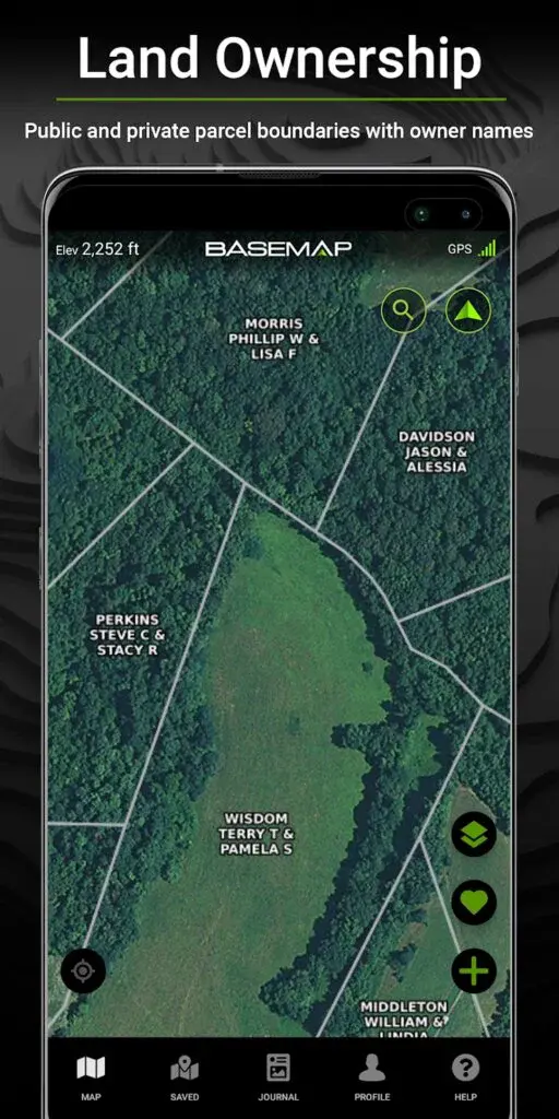
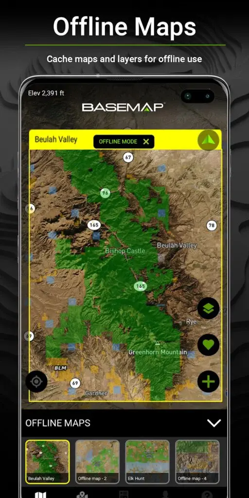
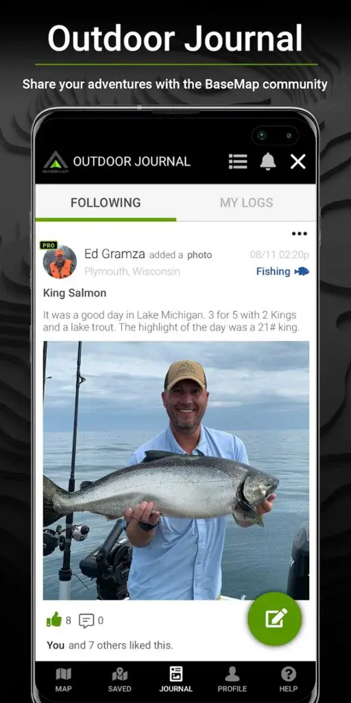
BaseMap is a superb tool presented in the market by BaseMap Inc. that enables its global users to get the private and public boundaries with the names of owners. BaseMap: Hunting & Fishing GPS Navigation Maps app features offline maps, cache maps, and layers and outdoor journal to share adventures with the community of BaseMap.
BaseMap Hunting and Fishing GPS Navigation Maps app feature map layers include more than 700 layers, nationwide leaks, streams and rivers, nationwide wilderness and Roadless areas, nationwide wildfires, and timber cuts, and much more. You can precisely know your exact location and explore where you are regarding property boundaries, peaks, trails, roads, and boundaries.
It features Google Earth Integration to view the terrain in true 3D and export makers and view them over the Google Earth. It also features water depths for West, Easy coast, Gulf Coast, Coast, and more than 4K U.S lakes intuitively. BaseMap: Hunting and Fishing GPS Navigation Maps app also feature multiple satellite and topography imagery Basemap options.
HuntStand is one of the most exquisite hunting apps that combines land-management and hunting right under one platform. HuntStand: Hunting Maps, GPS Tools, and Weather is a significant tool presented in the market by TerraStride Inc. that helps you create detailed and comprehensive custom maps and view them in a 3D view for free.
You can intuitively customize your maps while adding more than a hundred lines, shapes, and makers. Hunt Stand app also enables its global users to share their maps with friends and view their maps across platforms. HuntStand app lets you view, edit, and manage all the maps using ultra-advanced and comprehensive mapping capabilities.
You can create a personal profile, share maps with friends, add friends to your network, and locate your friends using its unique friend finder feature. You can also join group hunting areas and view advanced statistics build from your sighting history and personal harvest. HuntStand: Hunting Maps, GPS Tools, and Weather app lets you log in with simple clicks and enjoy all the features for free.
BackCountry Nav Topo Maps GPS is a beautiful app that helps you have off-road, rough, or cross-country Topo mapping GPS along with the most exclusive outdoor navigation. BackCountry Nav Topo Maps GPS is a magnificent tool presented in the market by CritterMap Software LLC. That helps you use Topo maps and GPS on hike trails without calling the service.
It uses your GPS location to provide your exact position from satellite and never lets you use the internet to use maps. You can preload free offline Topo maps, road maps, and aerial photos over your storage memory just to let you get things whenever you want.
Some of its inbuilt sources include USGS color aerial photography, outdoor maps of Austria and Germany, OpenStreetMaps and NASA Landsat data, Topo maps of New Zealand, and Topographic maps of Italy and Spain. So just give a chance to download BackCountry Nav Topo Maps GPS app over your cell phones and tablets to find your own ways while having fun outdoors and be a maverick by venturing into new territory.

Terrain Navigator Pro is a superb tool that provides a sleek, simple, and affordable solution for professionals and ordinary users to collect and transmit data from the fields to the office. Terrain Navigator Pro is a significant tool presented in the market by Trimble Inc. that helps you the map, discover, collect, and share field data intuitively. You can precisely make an instant mobile connection, share friends’ data via TNP desktop, and analyze GIS and GPS data at the office.
It serves the professional market, including rescuer and search teams, professional forecasters, surveyors, law enforcement, land managers, and other outdoor professionals without doing much. The Terrain Navigator Pro app is compatible with the TLGNSS Receiver (Trimble Leap GNSS), a sleek receiver with Android devices.
You can sleekly collect field data regarding tracks, videos, photos, audio clips, markers, and various other information in areas without data signals and internet connection. Terrain Navigator Pro app lets you view information on aerial, street, and topographical maps downloaded to the phone for use without the internet.

Visitor Map is an amazing application that helps you find the perfect spot over these expansive lands that features more than 158,000 miles of trails and over 43K campgrounds. Visitor Map: Map of Forest Service Lands is an engaging app presented in the market by USDA Forest Service that makes it easy to explore the most famous outdoors by visiting America’s backyard.
You can precisely find its rich cultural heritage at plenty of destinations right over your cell phones having Visitor Map. It features accessible recreation locations, national-level search capabilities, offline mapping support, streamlined and simplified map interface, and much more. You can also get the most precise weather and wildfire watches or warnings.
All these lands also play host to over 6K miles of scenic and wild rivers that provide leisurely rides passed breathtaking rollercoaster-like rides and exquisite scenery down rapids. Visitor Map: Map of Forest Service Lands app provides your year-round destinations, including photographic bursting colors of wildflowers, watching leaves change colors, and cooking s’mores around the campfire in the summer.

LandCentury is a magnificent tool that helps you get the free mobile marketplace for selling and purchasing real estate using cell phones and tablets. LandCentury: Buy & Sell Real Estate is a superb app presented in the market by NetWealth, LLC, making it easy to find your perfect deals and search wholesale properties in a breeze.
You can precisely discover exclusive listings, make an instant connection with people, and enjoy a results-driven profile and platform. LandCentury is one of the most elegantly loved and influential marketplaces for reasonable houses, vacant land, and cheap plots. You can precisely discover the data you are searching for and enjoy 100% free access to the site.
You can elegantly discover different owner financed properties and get information about all the wholesale opportunities in your area. Land Century: Buy and Sell Real Estate app provides detailed records over the property and enables you to filter by geographical location and know your targeted area with the right filters.

Rockd is an amazing app to explore lands, get to know new things, get dozens of documentation stuff, and know your geologic surrounding in a way like never before. Rockd is a superb tool presented in the market by UW Macrostart Inc. that makes it effortless to learn and explore the geologic record precisely. You can get the most precise information about the geologic record, log your journey over it, and contribute your observations as well.
It enables its global users to have instant access to your current location’s geographic and geologic summaries through its sleek dashboard. It provides interactive and beautiful global access to over 140 geologic maps available. You can elegantly see your current or past locations and discover paleogeographic maps from the GPlates and C.R. Scotese.
The app makes it effective to explore published content containing mentions of all the mapped geologic units. Rockd app helps you add your desired field observations even if you don’t have an internet connection and get the tag support from the Paleobiology and Macrostart database.

National Park Trail Guide is an amazing tool presented in the market by Adventure Projects Inc. that helps you discover the perfect national hike right using your cell phones and tablets. National Park Trail Guide – National Parks Guide and Maps is a magnificent app for you if you want to search hikes by using multiple tags of some of the natural gems available in the universe.
This application enables its global users to get a comprehensive guide to sight-seeing as well as hick over the National Parks. You can get the complete description and trail data from various national parks, including Yellowstone, Grand Canyon, Zion, Grand Teton, Mount Rainer, Point Reyes, Yosemite, Acadia, Great Smoky, Glacier, Rocky Mountain, and plenty of others.
It helps you plan the perfect trip if you want to hike some famous parks and get everything needed. National Park Trail Guide – National Parks Guide and Maps app provides star ratings, camping and lodging, food and drink, guided tours, information insights, season details, evaluation profiles, and almost all the necessary stuff.
RTKGPS app helps you get the sleekest and concise GPS positions while using PPP and PRT algorithms (RTKLIB) along with the help of supported external GPS as well. RTKGPS is a simple to use app presented in the market by Ronan LE MEILLAT that helps you fetch everything you need regarding your GPS positions to manage things precisely. You can also send mock locations to plenty of other services and apps.
It provides you with the options of server, map support, status, input streams, log streams, output streams, processing options, and solution options right over its sleek dashboard. You can get the altitude in the status view support just by choosing the height geodetic (in the solution Options view). It uploads solution files and logs files right to the Dropbox account for free.
The app displays geodetic altitude and ellipsoidal height while letting you use multiple geoid models. RTKGPS app precisely displays the results in WHS84 Lat or Lon, Lambert 93, UTM (with auto zoning), ECEF, NAD83 coordinate system, and various other formats.

onX Hunt is a sleekly designed and widely loved application for you to get property lines as well as land ownership maps right on the palm of your hands. onX Hunt: Hunting Maps, Offline GPS/Nav & Weather is a significant tool presented in the market by onXmaps Inc. that enables you to get the most comprehensive data regarding your location.
onX Hunt: #1 GPS Hunting Map app enables you to get private land boundaries, public land boundaries, color-coded land designation, landowner information, and various other information wherever, whenever. onX Hunt: Offline Land Maps – Sat & Topo app provides everything curated by an excellent i20 in-house GIS team. It provides a magnificent aerial view and sleek 4K topographical maps with GPS navigation.
You can effortlessly measure area and distance between blinds and tree stands and even measure acreage with shape tool as well. OnX Hunt: Hunting Maps, Offline GPS/Nav and Weather app lets you track distance, duration, coordinates, and speed of your hunt using GPS hunting tracker.
U.S. Topo Maps Free is an engaging Outdoor navigation tool that enables you to access the most significant aerial images and topographic maps for the USA. U.S. Topo Maps Free is a superb app presented in the market by ATLOGICS Geoinformatics GmbH & Co. that lets you choose between more than 20 map layers, including sea charts, aerials, flight charts, topos, and various others.
You can precisely download maps to use them offline usage and get real NEXRAD Weather Radar and nowcast Weather Information. It enables its global users to access over 100,000 USGS topographic maps seamlessly stitched with each other. It features open street maps, public land ownership, flight charts, Google Maps, Bing Maps, and much more.
It enables you to create and edit Waypoints, GoTo-Waypoint Navigation, route-Navigation, create and edit routes, track record with accurate profile, speed, and elevation. You can precisely get a trip-master with fields for the average speed, bearing, elevation, odometer, and much more. U.S. Topo maps free app also features NWS weather forecast, track replay, use coordinates, and much more.

MapItFast Easy Mobile Mapping for GIS app intuitively turns your iOS and Android cell phones and tablets into a robust record-keeping and mapping device whenever you want. MapItFast Easy Mobile Mapping for GIS is a superb tool presented in the market by AgTerra Technologies, Inc. that leverages the GPS of your device to generate precise records regarding your location.
It features one-tap mapping support that makes it secure and easy to measure and record all the activities out in the field. You can precisely create points, maps polygons, circles, lines, points, and geophytes to represent anything of internets in the field. You can precisely pause and resume GPS tracking, drop points, draw objects by hand without interrupting GPPs tracker, and take geo-photos intuitively.
It features GIS mapping tools such as Splits, Donuts, buffers, and various others. You can precisely have the options of sorting, copying, searching, editing, moving, and sorting maps among objects. MapItFast Easy Mobile Mapping for GIS app lets you import shape-files, user and group level project access, printable reports, and much more.

The Dyrt Camping App enables its global users to explore more than a million campsites, tips, and reviews submitted by campers like for the best R.V., cabin, and text sites all over the United States. The Dyrt All Campgrounds, R.V. Campsites, Glamping is an amazing app presented in the market by The Dyrt Inc. that makes it easy to search and filter your desired camps whenever you want.
It helps you get secure and instant access to get access to the most engaging and functional campaigning information in the United States. The Dyrt Camping App: Tent & R.V. Campsites Finder app includes reviews on such as Federal, State Parks, Country Parks, National Parks, KOA, Bureau of Land Management, Good Sam, Thousand Trails, Military, and more.
The Dyrt: Search All U.S. Campsites, Rated app enables you to filter review by keywords such as distance, ratings, cabin, R.V., text, rating, glamming, and more. The Dyrt All Campgrounds, R.V. Campsites, and Glamping app lets you save trips and request reservations in simple swipes.

QField for QGIS app intuitively focuses on precision and efficiency to get the fieldwork of GIS done in seconds. QField for QGIS is a superb application presented in the market by OPENGIS.ch Inc. that precisely combines sophisticated technology with a minimal design to get data from the field whenever you want. You can precisely get data from the field right to the office in a secure, easy, and comfortable way.
The app built on top of the professional QGIS open source project forms in QGIS on their workstation, allowing users to set up maps and deploy those in the field via the app. It supports a diverse collection of vector and raster formats, including OGR, PostGIS, GDAL, and more.
You can intuitively stores the datasets locally and accessed remotely and synchronized with Wi-Fi, mobile network, and USB cable. QField for QGIS is a sleekly designed tool that helps you store, capture, and manage data from the field right at your office without letting your make any effort or spent any money.

CarryMap app enables you to view and manage maps everywhere you go and enjoy all its features without any need for the internet. CarryMap is an excellent tool presented in the market by Data East, LLC, that helps you download free maps covering various territories and use maps prepared in ArcGIS from its gallery. All the data provided by the maps in the gallery is truly based on the Open Street Maps data.
You can intuitively create and edit line, polygon, point, and other features available over the map in the field. It brings identifying and searching features offline, measure distance and areas, and share data in plenty of formats, including SHP, KMZ, KML, GPKG, GPX, and various others.
It also enables you to create polygons using a GPS tracker, add graphics marks to the map, add attachments to features, and precisely print all the selected map areas. CarryMap is an elegant map that helps you access maps to work, view, and manage things with mobile maps over Android and iOS tablets and smartphones.

Locus GIS offline geodata collecting, SHP edits is an efficient and professional GIS tool for fieldwork geodata without using the internet. Locus GIS offline geodata collecting, SHP edits is an amazing application presented in the market by Asamm Software S. R. O. that precisely displays data over the map to grab all the significant information. You can precisely add attachments and metadata and even create or edit geometry without doing much.
The app provides data collection, updating, viewing, and managing with simple swipes. The app is used in a wide range of industries, including the collection of environmental data, agricultural and soil management, planning and construction of wind farms, survey and management of urban facilities, exploration of mining fields and location, and various others.
Some of its tools and features include measuring areas and distances, style editing and text labels, organizing data into projects and layers, and searching and filtering data in the attribute table. Locus GIS offline geodata collecting, SHP edits app supports a diverse range of maps to download or use online.
Mapit GIS Map Data Collector & Measurements is a stunning, professional, cost-effective, and stand-alone surveying and mapping platform available over your cell phones and tablets. Mapit GIS – Map Data Collector & Measurements is a superb tool presented in the market by Mapit GIS LTD Inc. that helps you enhance the productivity of surveying while you are working in the field.
It supports almost all the common file formats for output and input and is significant to work with a number of GNSS receivers in extreme accuracy. Mapit GIS Map Data Collector and Measurements app enable you to design your own surveys, work offline with mbtiles base-maps, organize data on layers, and access WMS services. You can precisely use GPS tracking to record your polygon and line features and captures GNSS metadata.
It supports four methods of collecting data such as GPS location, Map cursor location, GNSS location, and point projection using distance and angle. Mapit GIS – Map Data Collector and Measurements app feature offline mbtiles and online maps selections.

Landgrid Map & Survey Property makes it superb to fly over the map of the Landgrid and get plenty of sleek information regarding the property in a way like never before. Landgrid Map & Survey Property is a stunning app presented in the market by Loveland Technologies Inc. that makes it easy to get the details of land right on the palm of your hands.
You can elegantly get the map to view the tax details, ownership of the land, and property data for more than 140 million parcels from all over the globe. Landgrid Map and Survey Property is a stunning application for all the people looking for an app to conduct state-wide, city-wide, or neighborhood surveys without any prior efforts.
You can put all your paper forms and spreadsheets over the app and put everything regarding your surveys right over your cell phones. Landgrid Map & Survey Property app has made mapping and surveys to grab different information about your city easily.
PropertyRadar app makes it superbly amazing for commercial real estate managers, residential businesses, and business professionals to intuitively manage real estate. PropertyRadar is an amazing tool presented in the market by PropertyRadar Inc. that brings a precise property owner and discovering platform for closing more deals in hands. You can precisely discover lists with more than 200 criteria drive for dollars using the GPS and visualizes with heat maps.
You can intuitively add your desired photos over the areas available on the map and even get comprehensive property and ownership information. You can instantly discover the lists of customers using more than 200 criteria or dozens of Quick Lists and highly targets prospects.
The app covers most of Arizona, Oregon, Washington, California, Washington, and various others. It helps you explore your markets such as city, neighbor, region, and even the street at your desired level. Property Radar app lets you sync data between devices and access more than 20 million details over the property.
GIS Surveyor Land Survey and GIS Data Collector app focus on the land survey, GPS and GNSS survey, and road construction surveys. GIS Surveyor – Land Survey and GIS Data Collector is a superb app presented in the market by PoloSoftech Inc. that enables all the professional surveyors to collect data in a stipulated time frame and manage things flawlessly.
It is an excellent GIS remote sensing app that you can use for GIS mapping in a way like never before. You can use the app with plenty of environmental as well as field surveys while also enabling the collection of GIS data in a fast and efficient way. You can use the app for field surveys, land surveys, environmental surveys, and surveys of other natures.
Some of its top features include a GIS data collector, a GPS land area calculator, calculate the distance and area. GIS Surveyor – Land Survey and GIS Data Collector app helps you have surveys via images, surveys on online GIS maps, WMS and WMS surveys, and various export file formats.

LandGlide is a superb parcel data mobile app that enables you to hover property to view details and get the most comprehensive data without any effort. LandGlide – Parcel Property Boundary Lines is a significant tool presented in the market by Real Estate Portal USA Inc. that enables you to explore maps using the GPS technology in a way like never before.
You can use GPS technology to pinpoint your location whenever you needed your current location. This app lets you explore maps and access more than 150 million parcel records in more than 3k countries (covers almost 95% of the U.S. population). This application precisely displays the property owner, boundaries, address, sale price, school district, parcel I.D., address, and more.
You can also drop your desired number of pins to save the respected property, export all the saved properties, and add notes by property. LandGlide – Parcel Property Boundary Lines app is an elegant tool for real estate, outdoor recreation, insurance, delivery, utility, energy, and emerging industries.
Map Pad GPS Land Surveys & Measurements app makes it so effortless and secure to calculate distances, perimeters, and areas and export, share or save your measurements whenever you want. Map Pad GPS Land Surveys & Measurements is a superb application presented in the market by Mapit GIS LTD Inc. that brings plenty of sleek features for measuring your desired stuff.
This app brings a multi-purpose mapping solution enabling location capture and regulates measurement distances. You can also calculate the area for the shapes available over the map and capture using GPS tracking. It features all the base maps, including Bing Maps, Open Street Maps, Google, Maps, and various others.
You can get accurate measurements of distances or areas along with three methods of measurements, including Map cursor location, Tap on the map, and GPS location. Map Pad GPS Land Surveys and Measurements app enables you to add or edit titles, export single or multiple waypoints and measurements, elevation profile availability, import GPX, and KML files, and get GPS or satellite statuses.
BackCountry Navigator X.E. Outdoor GPS App brings the next compeers of the stuff for exploring the locations via GPS online as well as offline topo maps over your cell phones and tablets. BackCountry Navigator X.E.: Outdoor GPS App (New) is a superb tool presented in the market by CitterMap Software LLC Inc. that brings an exclusive app that helps you get plenty of amazing features right on the palm of your hands.
This app lets you achieve several goals using this brand new platform along with the touch of some old functionalities. The web interface of its website helps you plot routes, boundaries, and points and even download them in the mobile app. It helps you get push trips to the cloud and over phones for instant sharing and reviewing.
It helps you get a sleek approach for choosing large squares and organizing and downloading offline maps. BackCountry Navigator X.E.: Outdoor GPS App (New) app also features Vector Topo Maps for the world to hold the promise of comprehensive details.
Mobile Topographer GIS makes it effortless to complete surveys without any tension of getting into complexity and the volume of data. Mobile Topographer GIS is a significant tool presented in the market by S.F. Applicality Ltd. That helps you in collecting GNSS readings using extreme precision. It enables you to collect GNSS using GPS< Galileo, QZSS, constellations, GLONASS, Beidou, and some others.
The app displays data in local projected CRS as well as into WGS84 along with real-time projection on the map. It supports the instant conversion of local projected CRS into WHS84 or vice versa using cell phones and tablets. You can instantly discover all the marked points in the real world using the Drive Me option.
The app helps you create 3D terrain of the area, store routes with data, show GNSS satellites, collaborate with partners, show GNSS satellites with signals, store routes, and exchange jobs. Mobile Topographer GIS app also enables you to share jobs between P.C. to the mobile phone using all formats, including CSV, DXF, TXT, and various others.

DealMachine for Real Estate Investing is a significant tool that helps you get to know all the things regarding the real estate without letting you do much. DealMachine is a significant tool presented in the market by DealMachine L.L.C. that intuitively looks up the owner of the property, and sleekly sends all the necessary details right away.
This application elegantly helps you get the most secure and precise information regarding property and helps you organize your properties whenever you want. This app enables you to get all the in-depth analysis and deeper insights over all the deals and lets its global users monitor the ROI with ease.
It enables you to instantly see the information of the owner and get all the public records from the property available to use in the USA. DealMachine for Real Estate Investing is a genuine and robust tool for precisely measuring a driving for dollars, and its exclusive team is making it more precise and better than ever for real estate investors to maintain all their REI business.