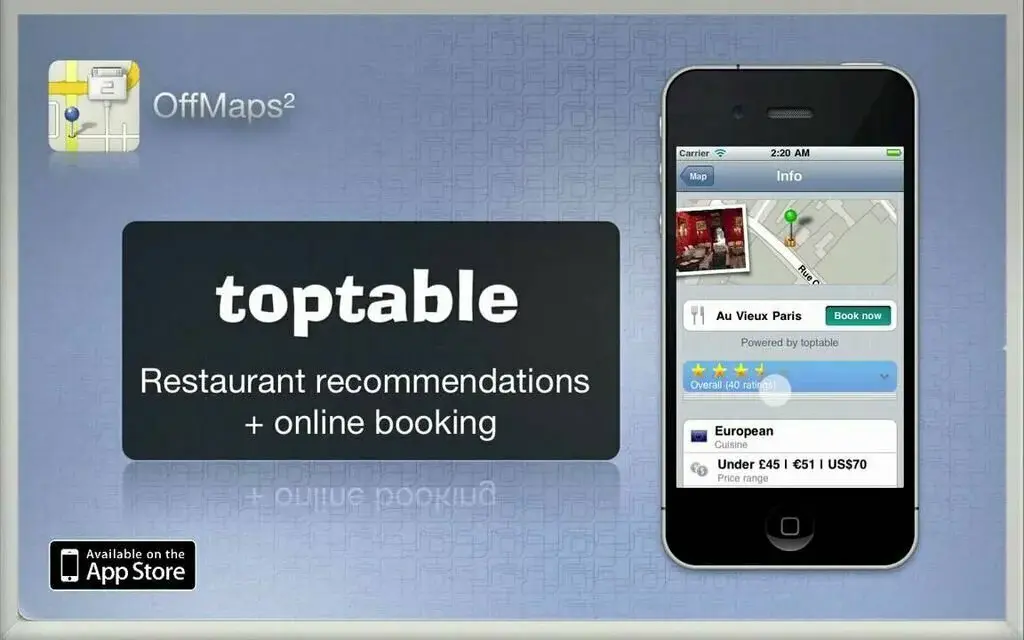
OffMaps 2 is a well-designed app which allows you to access searchable maps offline. It can store your maps directly to your device and allow you to search the map offline. You can save data roaming charges and Turn your iPod into a fully featured travel guide. The free version of OffMaps has 2maps, but you have to purchase additional maps at $0.33 per map. The user can find here restaurant menu and recommendations by the top table and can reserve a table directly for dinner. OffMaps 2 update its maps on a monthly basis. OpenStreetMap is the source of OffMaps 2 to get information because a massive data from ATMs, bus stops, restaurants, bars is present on OpenStreetMap. OffMaps 2 is an ideal travel guide because Wikipedia have entries on the map, and you can read everything about the Eiffel Tour, Capitol Hill or Grandenburg Gate. It is compatible with iPhone, iPad, and iPod touch.
The Google Maps is mapping app created by Google. It will find for you the best spots in town and the information you need to get there. Google Maps is an extensive app with accurate maps of 220 countries and territories. It will also have Voice-guide GPS navigation which will help you for driving, biking, and walking. You can find there a collection of Transit directions and maps for over 15,000 cities and towns. This app will search for you the best route for you with the help of live traffic conditions, incidents reports, and automatic rerouting. Detailed information of more than 100million places is present on Google Maps. You can see there street view and indoor imagery for restaurants, museums, and more. Some feature of Google Maps is not available in some countries. Continued use of GPS will decrease your battery. It is a free app available in more than 30 languages.
Open Maps is a mapping app mostly used for offline use and map editing. It has a digital compass that can help you to rotate the onscreen map to match the direction you are facing. If you are not using location services, then you can turn it off to reserve battery. By tapping on the icons on the map, you can find more information about those places. Open Maps allow users to add custom map types that they can browse.
You have the ability to download maps for offline use, but it is strongly discouraged because you maybe do not get the map service due to abusively downloading. By geo tweets feature, the user can search out a tweet of different people around you or anywhere in the world. Open Maps lets you do some basic edits like editing tags and adding new places. You can set transit points for the routes and bookmark the routes for further use.

The one of the best features of City Maps 2Go is that it works offline. So it has a collection of Offline Maps, and you will search here new places according to your choice. On this app, 1st collect all information about the different location then saving it in City Maps 2Go library after organizing. Make your trip best with the help of City Maps 2Go. No roaming and hustle are required because free offline maps are available at City Maps 2Go. According to Time Magazine City Maps 2Go is the Essential app for travelers. Over 15 million people have installed this app on their smartphones. You will get interesting stories about your favorite places. Without an internet connection, you can see your location on the map by GPS. The pointer on your screen will tell you about your direction of walking in streets. You have to type the name of your pacific place; you will get all details of that location. Also, give a rating to your favorite place and create your reviews. Help others by sharing these tips and recommendations with your friends and other travelers.

CityMapper is the best transit app making sophisticated cities easy to use. Data from a large number of famous cities is available in this app. Information about all modes of transportation like subway, ferry, Uber, Bus, and car sharing in those big cities are present on CityMapper. So managing to your trip according to your budget is easy through this app. All transit maps, Real-time departure, Line status and real-time disruption alerts will inform you about updates. CityMapper will combine all possible modes of transport and choose the best option for you to travel. Alternatives are also present to disrupted routes. CityMapper is the Apps of the year for Apple’s 2013 and 2014. Thousands of 5-star user reviews are accessible on CityMapper. CityMapper works with SMS, WhatsApp, Twitter, and Email. You can send your GPS coordinates & map location to anyone through CityMapper.
OsmAnd Maps is a map app which is worldwide and high-quality OpenStreetMap data. It can store all map data on your device memory for offline use. Without access to the internet, the user can perform all functions like online mapping. It will display your position and orientation. It will automatically align map according to your direction. This app has a new feature of favorite, where you can save your most important places for frequent use. OsmAnd Maps will collect for your high-quality information from the best collaborative projects of the world. Maps of this app are updated every month. The user can share his location with his friends so that they can easily find him. One of the amazing features of this app is that it include foot, hiking, and bike paths, ideal for outdoor activities. Everyone can share his information with OsmAnd Maps by reporting bugs, improving translations and coding new features. Most of the countries are available here as map downloads.

HERE Maps win the “Best Automotive App” award 2015 from Auto Bild! If you are looking for offline mapping and navigation, then check this app because the information from more than 100 countries is available. Here the world is around you, and you can explore new places without worrying about getting lost. With HERE Maps, plan you’re ahead of time and save different maps for your destination on your smartphone. Maps of more than 100 countries are present here, and you will never lose with an offline mapping facility.
The route planner is a feature of HERE Maps, which will show you’re driving, public transit, and walking options. This app will help you to drive with turn-by-turn, voice-guided driving, and walk navigation will take you to your right destination. The user can search here transit maps and schedules to move around by train or bus. HERE Maps has a collection of public transit maps, directions, and information for more than 900 cities.
2GIS is map application used for offline mapping and business listening. Trusted information about different restaurants, bar, and hotel are present on this app. It will provide you 3D-maps of more than 180 cities and contacts of over 1.5 million companies including public institutions like hospitals, schools, police stations, etc. This app can access your addresses, phone numbers, e-mail addresses, working hours and payments of these companies. This app will allow you to find the location of the business you are looking for and search out its phone number to make a call. Car routing and searching for public transport routes are available on 2GIS. It will help you to find your exact destination by car or by public transport and identify your location to see what is close to you. After installation of 2GIS, the user can select the city of your need to download the data. Internet connection is not required to operate with directions and maps. The information on this app is updated every month.

MAPS.ME is one of the quickest ways to find out your destination. The user can access here detailed maps of all countries from anywhere in the world without an internet connection. Over 30 million people have trusted MAPS.ME by downloading it. It will help you by giving directions to your exact location. It is a useful app at home and necessary for travel. MAPS.ME is covering 345 countries and islands.
Detailed information is present, and millions of points-of-interest are here to discover like restaurants, destinations, gas/petrol stations, ATMs, and much more. MAPS.ME contains highly up-to-date, which is added by map users all around the world. It is one of the fastest mapping apps, and you can save maps on your smartphones. The user can share his location on the map via email or SMS. The auto-follow mode is one of the stunning features by which the map automatically orients itself to the direction of your moving.

MapQuest is a one of the fantastic apps because it has different features like Mapping, GPS, Navigation & Traffic. This app will help you live like a local in any area of another country. You can search here nearby points of interest like restaurants, gas, hotels, etc. The user can find his destination faster by using advance research to see contacts, recent searches, top categories and nearby POI. It will simplify your life by finding for you best mode of transportation based on the time of day, weather, and cost. MapQuest will give you information about the rubber-necking and route around accidents so that you can search for alternate routes to your destination. Different transportation options like Uber, car2go, and local transit will help you to get the best choice to move. View here local weather condition to plan the better mode of transportation. If you forget your work, home, and other addresses then bookmark them so you can easily access them from “Go To” on the home screen.
Yandex Maps is a mapping app having offline maps for 200 cities. The new version of this app has a world map, city guides, routes for cars, and public transport. This application has a collection of vast databases of organizations and you can use a filter to search your particular organization. Important details of well-known organizations including contact info, office hours, service information, photos, and reviews are present on this app for search.
A feature of “My Places” is part of this app where you can save your view locations for further use. Several journey options are there for you to choose the best route for travel avoiding traffic jams. This navigator will guide you step by step along your way. It will update you with real-time information on heavy traffic, speed cameras, roadblocks, and accidents. Maps in this application are updated daily to keep you informed about your city. The user can get the city’s traffic information and home or work journey times on his Apple Watch.

zMap is a mapping app that provides both facilities of offline and online mapping for navigation. This app is using different map sources like Google Maps, OpenStreetMap, and Nokia Map. The user can save different searching locations and routes in various transparent modes like driving, public transit, walking, and bicycling into bookmark then read at the offline case. Without an internet connection, you can use an iPhone, iPod, or iPad for offline map navigation during travel.
Versatile map tiles formats like MBTiles, Galileo, XGPS, RMaps, Big Planet, and OsmAnd are supportable at this app in offline mode. It can import maps, locations, and direct files from Apple iTunes sharing or other apps. zMap has a function of Flexible zoom-level for offline map tiles, which allow the user to prepare the map tiles data flexibly and reduce the data size.

Galileo Offline Maps is a mapping app used for offline vector maps and offline search for better experience. It is an entirely free app with no limit on the number of countries for download option. This app based on OpenStreetMap so you can get detailed information about every destination. It works very fast and get less space than others apps. One of the amazing features of the app is the changeable size of labels because you can get better information from large labels during driving. In offline mode, the user can search a location with a variety of ways like by object name, category or even by GPS coordinates. You have the ability to record your trips and can export them as KML/GPX files. Galileo Offline Maps has the option to mark your favorite places on your maps and for your next trip, set point of interest. Different icons are available to add to your bookmark. This app allows you to share your itineraries from the app with your friends by Mail, Facebook, and Twitter.

Map Plus is a mapping application which has one the most powerful and flexible tool for editing and viewing custom maps. This app has an ability which will allow you to use Map Plus as a professional GIS tool to do geographic data gathering, editing, measuring, sharing and much other management. A Large number of online and offline maps can be customized and viewed. You can import new maps from NOBAC’s map source XMLs, LUA scripts, QR codes and iOS cache. Two different projections like “EPSG:4326” and “Web Mercator” can be supported by Map Plus. It has a feature of displaying photos and videos directly on the map. The user can see street views of most of the cities all around the world including cities of China. It will allow the user to import and export data as CSV files, which may contain custom properties and tags. You have the ability to share or transfer data by Wi-Fi, Bluetooth, iCloud, SMS, Email and many other ways.

WikiPlace is one of the best mapping app describing every location of the world. Wikimapia.org is accessible by using WikiPlaces. Over 20 million places around the globe are now on your smartphone with the help of this app, and it also has a complete description, photos, and user comments for these places. You can search here different locations with name, ID, and address. Save your favorite places and arbitrary to Bookmarks and find them quickly when you need it.
“Classical” visual style is also a part of WikiPlaces for old school Wikimapia fans. You have to touch and hold any location on the map to see its address, coordinates, or if you want to share it with your besties on social media. The free version of WikiPlace is ad-supported, but you can remove advertisements via In-App Purchase. This app is available for both iPhone and iPad with over 30 different languages.