
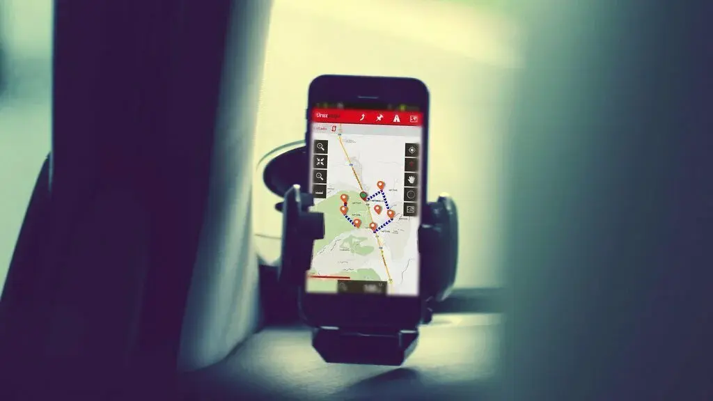
OruxMaps is a great tool which helps you get an elegant map viewer and track logger. OruxMaps Donate bought in the market by Jose Vazquez Inc. through which everyone can have a tool for running, mountain biking, paragliding, nautic sports, trekking, and other outdoor activities. This app lets you have both offline as well as online maps, and you can also use maps from the Ozi Explorer altered with a PC tool. OruxMaps Donate brings GeoPDF from USGS store, Qtopo Australia, Natural Resources Canada and various others. Apart from this, OruxMaps Donate features GeoTIFF support, img garmin, mbtiles, map, (vectorial from mapsforge), and rmap, etc. Orux Maps Donate app also supports some external devices which include GPS Bluetooth, Polar, Bluetooth Zephyr, Heart rate monitor, cycle power BT 4.0 sensor, Cycle cadence and speed BT 4.0 version, and AIS info systems. It also supports ANT+ which includes speed, heart rate, distance, temperature, cycle power, and cadence. You can download both online and offline maps and also support text to speech recognition factor. It also displays the position of your friends and other, and you can even share your locations with others. So just download OruxMaps Donate app and enjoy various of its features.

Google Earth is a tremendously used map and navigation application introduced by probably the most renowned developer Google LLC. Google Earth is an astonishing app that enables you to orbit the entire world in three-dimensional view to see it from every angle. This widely used maps and navigation app enables everyone to explore the whole world from above with the 3D terrain and satellite imagery of the 3D buildings and entire globe in thousands of cities from all over the world. Google Earth allows you to search any location available on the Earth and enables you to explore everything they contain. You can precisely zoom in to your house or anywhere you want to know by diving for the 360 degrees perspective with the street view as well. You can set off on a unique adventure by rolling the dice and hopping between so many random locations. Google Earth lets you see the world from an entirely new and unique point of view with the Voyager. Voyager is a stack of guided tours from BBS Earth, National Geographic, NASA, and various others. So just download Google Earth app in your phone and get to know the exact location of your desired places right from your sofa.

HERE WeGo is a widely loved app to see as well as compare ways to get around you areas and enjoy maps on the move. HERE WeGo – Offline Maps & GPS bought in the market by Here Apps LLC which makes it easy to get around town and use maps to navigate even without an internet connection. This app enables you to get directions to anywhere you desire and get other information you need to go from one point to the next to your way including car sharing prices, transit ticket, departure time, and various other information. Whether you have a car, bike, cycle, or any public transporting, HERE We Go lets you have directions to your desired destinations with comfort and never let you get the wrong or the lengthy path. HERE WeGo – Offline Maps & GPS precisely shows you all the ways perfectly to get around so that you can compare them easily and pick what is best for you. It lets you have the entire knowledge about the route before you head out. So just download HERE WeGo – Offline Maps & GPS app in your phone to enjoy the extremely talented and best guidance for your future journeys.

Google Street View is extremely loved application used by billions of individuals from all over the world to explore the world with damn precision. Google Street View is another classy product by Google LLC which have introduced a platform through which you can discover as well as search natural wonders world landmarks, and even step inside locations such as restaurants, museums, restaurants, small businesses, and lots of other stuff. It enables you to add your own Street view as well to see whatever you want. You can even create 360 degree pics using either your certified Street View Ready camera as well as your very own mobile phone’s camera, then position them and add connection over the map through this classy app. Google Street View brings is a marvellous app for local guides and all the travelers who often went to new places for their work or anything else. You can take an eye over the view as you walk, drive, or bike. It also brings a brand new video feature where you can connect to the camera to create street view and it allows you to record videos from your camera and convert it into street view images. So give a chance to Google Street View app, and enjoy extremely concise map and navigation for your desired places.

NASA enables its worldwide users to explore and discover the latest images, videos, news, feature stories, tweets, mission information, NASA TV, pics, and featured content with this superb app. NASA enables you to grasp a collection of more than 16,000 images and is keeps on updating day by day to let you acknowledge everything new. You can precisely get and read all the latest featured stories and news which seems like interesting and also watch more than 14,000 NASA videos from around the agencies. It enables its users to discover the latest NASA mission info and also lets you view upcoming sighting opportunities for the ISS (International Space Station) and get notifications. You can also watch live streaming videos from the HD Earth Viewing experiment on the Internet Space Station. Other than these, NASA also lets you grab latest tweets from around agencies, rate images and make them be trendy, select your own favourite missions and images, get information links, and so much more. NASA also displays the satellite tracking 3D and 2D maps earth models with the ISS and other Earth-orbiting satellites. So just download NASA app and get to know everything about Earth.
Navmii is a gorgeous app which brings free GPS navigation that works without even internet and so many other features for its worldwide customers. Navmii GPS World (Nav free) bought in the market Navmii Inc. which intuitively combines the voice-guided navigation, local searching, the point of interest, local searches, driver score, and so much more. It contains effective voice guided turn by turn navigation with spoken street names. There are more than 24 million drivers use his app for their path guidance, and its maps are available for over 150 countries. Some of its outstanding features include offline and online address searching, community map reporting, Head-Up display, HD accurate maps, driver scoring, and is working with GPS only (internet not needed). Navmii GPS World (Nav free) enables its entire users to search using postcards including city, street, the point of interest, and various others. All of its offline maps are stored locally and can be used whenever you want without an internet connection. This app also carries local place searching as well which is powered by TripAdvisor, What3Words, and Foursquare. So just download Navmii GPS World (Nav free) app in your phone and get extreme help for your all your journeys.

Mapy.cz will leads you towards any of your desired destination in the whole world. Mapy.cz – Cycling & Hiking offline maps bought in the market by Seznam.cz A.S. Inc. which enables you to have an extremely precise trip organization for all your journeys. It never let you forget your places, and all you need to do is to take your device with you for all the time along with this app. It helps you know about every trail so that you would not miss any single outlook, castle or any other attraction. You can intuitively save your routes and places to files and also sort them by trips to share them with others. Mapy.cz – Cycling & Hiking offline maps also lets you display ATMs, restaurants, stations, accommodations, Banks, public transport timetables, parking zones, and various others places that may come in handy. It lets you have an offline tourist map of the world with market tourist bikeways and trails right in your pocket. You can precisely get the satellite map of the world along with the panoramic photographs of 3D view and Czech Street. So just give a chance to Mapy.cz – Cycling & Hiking offline maps app and enjoy your trips stunningly comes to a safe end.

Scout brings an elegant way to connect not just places but also people for all their meetings, get-togethers, dates, parties, or any other patch ups. Scout GPS Navigation & Meet Up is probably the only social navigation tool that helps you share your favourite places with friends to eat, plan meetups, get turn by turn GPS voice navigations, and even share your ETA with them. This app enables you to set up your plans, add the number of people you want to call and enjoy your trips went great. You can do both text or voice chat with your friends to get things done properly. You can also decide your most desirable place to meet, and at the time of the meeting, this app will precisely show everyone the position of others and let you have the exact time of their arrival. Scout GPS Navigation & Meet Up also brings some brand new features for letting you have more comfort by letting you connect with others, share your ETA, enjoy voice navigation and searching, say hello with voice chat, and always be on time. So just download Scout GPS Navigation & Meet Up app in your phone and enjoy the most desirable social GPS and Navigation tool along with your friends for free.

Street Panorama is a gorgeous app which helps you enjoy simple street panorama view along with maps and navigation service as well. Street Panorama View bought in the market by MobileRise Inc. through which you can enjoy getting acknowledgement regarding all the famous streets of all over the world along with their precise descriptions. It enables you to touch My Location button and precisely see the street panorama view of the location that you want to search. This navigation app is beneficial for travellers and locals to get the panorama view of their desired places. Street Panorama View makes it easy to search address and see previews of the addresses. You can also press the full-screen button present on it to view the native maps app. It also carries a game mode which brings a combination of engaging design as well as provides acknowledgement regarding the places present on earth. In its game, you have to guess the country of the random street panorama view. It also brings a time killer mode termed as random street which lets you enjoy a closer look to the art projects, places, and museums from Unesco’s World Heritage. You can download Street Panorama View for free to have all this stuff right in your pocket.

CoPilot USA is an all in one reliable offline maps, powerful trip planning, and accurate traffic alert app through which you can get benefits without spending any single penny as well as wasting your time. CoPilot USA – GPS Navigation is built for you as well as the drivers to explore the whole world right through some simple taps. You can plan your routes with up to 100 stops so that you can spend more time earning or enjoying when driving. This is a must-have travelling tool for travel enthusiast to explore unknown locations for any of your desired working conditions. CoPilot USA – GPS Navigation brings a powerful planning that helps you prioritize your stops, lower fuel costs, optimize your route, and also spend less time in the car. This excellent GPS and navigation tool saves both of your fuel as well as time by letting you get the shortest possible path which is even clean with traffic thickness. This app optimizes your trips with smart routing and lets you save your money for your trips. So give a chance to CoPilot USA – GPS Navigation app by downloading it, and enjoy your safe, cheaper, and perfect journeys.
All-In-One Offline Maps is a superb app which stores all the maps intuitively to your phone after its download and remains them available, even without any internet access. All-In-One Offline Maps was introduced by Psyberia Ltd. through lets you have much more than just roads on your maps. It helps you get everything you need by letting you have all the things that a full-fledged online app contains, but in offline mode. It never let you get lost over any place when you go abroad and makes everything stay available for you even when the network coverage is so poor. This app reduces your data usage by providing you everything off line. This app has stacked all the maps in layers with precise opacity control. All-In-One Offline Maps makes it handy to select and store large areas in a few clicks, and you can view or delete them whenever you want. This excellent tool displays, store and retrieve limitless landmarks, and you can also add waypoints, areas, tracks, routes, icons, and various other items over the maps. So if you are bored to wait for maps to display, give a chance to All-In-One Offline Maps app, and enjoy everything so properly and in the way you wish to have.

AT&T Navigator is a fine map and navigation tool introduced by Telenav, Inc. which enables its worldwide users to get all the essential maps and traffic info on the move. AT&T Navigator: Maps, Traffic lets you beat traffic, share your travel details, explore local places, discover cheap gas price options, and various other things right from your cell phone. No matter what or how long the journey, it navigates your way around traffic. This GPS tool is powered by over 100 million traffic resources so that you can never be stuck in bad traffic and does not even burn your fuel for no reason. It is a superb app for planning your trips along with super precise traffic updates, one-touch traffic avoidance, GPS enables multi-route recommendations, and more. AT & T Navigator: Maps, Traffic is one shop stop for hearing and speaking directions, calculating and sharing ETA, get suitable gas prices, and various other things. It is one of the most emerging and trusted guide that helps you explore any of your desired places with detailed maps and recommendations no matter if you want to drink, shop, or play. So just download AT&T Navigator: Maps, Traffic app and enjoy precise outings for our daily commute, taking local city attractions, shopping, or everything else.

Earth-Now is an excellent and widely used application that enables you to intuitively visualize the most recent global climate data from Earth Science satellite right through your phone. Earth-Now is a great tool bought in the market by Jet Propulsion Laboratories which enables you to get all the necessary details and information about the earth. This app allows its users to visualize global weather and climate data such as surface air temperature, carbon monoxide, carbon dioxide, Ozone layer and its specifications, water vapor pressure, as well as sea and gravity level variations. You can intuitively notice everything regarding the changes which is going to happen concerning the climate. It also visually describe data using the false colour maps as well. Earth-Now also lets you have the 3D model of Earth and can easily be rotated by a single finger stroke and may also be zoomed in/out by pinching two fingers. It enables you to select a data map from its queries including air temperature, sea level, sea surface salinity, visible earth, water vapour, and various others. This app was developed by the ESCVT (Earth Science Communications and Visualizations Technology) development and application team at NASA Jet Propulsion Laboratory.

Earth Map Live GPS makes it easy to enjoy a 3D view of streets navigations and drive what you are looking for. Earth Map Live GPS: Street View Navigation Transit is a classy product by Appsclub Inc. which enables its users to see the clear map earth street view with navigation and routes. It is a simple and effective tool that brings even more features of earth mapping, location sharing, saving backup history, route tracking, and various others. It is an extraordinary place searching tool with live location satellite world map. It precisely lets you tracks and view your movements with the GPS tag smartrack, GPS tracker, advance earth map and ndrive route planner as well. Earth Map Live GPS: Street View Navigation Transit is free on Android platform and provides multiple maps type satellite mapping, 3D navigation map, 2D navigation map, and information about all the world places right through your cell phone. Apart from that, this Earth Map app also brings info about the fast track airports, bus stop, railways station, airlines for online ticket booking, and various other things. So just download Earth Map Live GPS : Street View Navigation Transit app from the store and enjoy exploring the whole world on your cell phone devices.

Sygic Travel Maps Offline is a fabulous app that helps you discover all the unseen stuff that you never notice while on a journey to abroad. Sygic Travel Maps Offline & Trip Planner bought in the market by Sygic Maps Navigation Inc. that lets you discover the awesome place and enables you to travel maps worldwide coverage even in offline mode. It is an advanced trip planner which intuitively builds an entire day to day itinerary for your outings with an ultimate trip planner. You can precisely watch the estimated travel time and even the walking distances to keep realistic plans. You can also invite your friends to collaborate over your trips and meetings. Sygic Travel Maps Offline & Trip Planner app brings one of the most exclusive worldwide offline maps, and you can buy its premium version to use it without an internet connection. You can also take a look around in exclusive 360-degree videos and enjoy a collection of 500 videos from Prague, Barcelona, Madrid, Seville, Porto, Lisbon, Athens, Tel Aviv, Jerusalem, Vienna, and various others. So just download Sygic Travel Maps Offline & Trip Planner app in your phone to enjoy an ultimate all in one tool for every traveller to get around with stunning travel guide.
Voice GPS Navigation & Maps Tracker helps you get the ultimate right directions towards any of your desired destination, introduced by SUMF Apps. Voice GPS Navigation & Maps Tracker makes it easy to discover any place where you want to go. This app also brings voice GPS maps and navigation which consolidate the most precise location over the maps with its elegant map tracker. It also lets you have Waze GPS traffic notifications and live navigation with Sygic GP navigation. It brings a brand new voice commands control GPS navigation and map tracker that helps you drive nicely. This useful tool also lets you know about the live traffic updates to drive speedily and without any frustration of being trapped in the traffic. Voice GPS Navigation & Maps Tracker features City maps, Track the shortest path, Maps design for travellers, Accommodation, Tour and activities, Distance calculation in kms, Time duration, 3D Live street Panorama, and several others. This app also lets you have multiple waypoints and alternative routes on course address. So just download Voice GPS Navigation & Maps Tracker app in your phone and enjoy satellite view, rail line tracking, navigation and route finder, Nessa, finder, earth live GPS satellite route, and various other benefits.

Voice GPS Navigation Maps Driving also enables you to get an elegant voice GPS navigation maps helps you get voice guider and driving a car driving roadmap altogether. Voice GPS Navigation Maps Driving bought in the market by Brandsapps Inc. which perfectly build out a complete route by drawing coordinate from your current location to your speak up drop off locations as well as providing you with the satellite view. It enables you to have offline voice GPS navigation app with maps driving directions that can take you at your goal with your desired shortest path along total kilometre calculation and estimated time interval. It features quickest route planner, earth maps, transit tracking, voice navigation with spot map, GPS route finder, weather maps, live street view, offline maps and GPS, driver distance history, and street view live 3D, etc. Other than these, Voice GPS Navigation Maps Driving also brings live traffic updates, pedestrian navigation, maps navigation live, GPS navigation for the car, GPS satellite route map direction, and so much more. This app will precisely lead you towards any place with voice guideline so a user can perfectly get instructions on every turn. So just download Voice GPS Navigation Maps Driving app in your phone to make sage and relaxed journey.

OsmAnd+ is an elegant map and navigation app that enables you to access to free, worldwide, high-quality OSM (Open Street Map) data. OsmAnd+ — Offline Travel Maps & Navigation bought in the market by OsmAnd Inc. which enables you to enjoy voice and optical navigation, creating and managing GPX tracks, viewing POIs, using contour line visualizations and altitude information, a choice between pedestrian tracks, cycling, driving, OSM editing, and so much more. This app works both offline and online and lets you get turn by turn voice guidance. This app helps you get optional lane guidance, estimated time of arrival, street name display, supports intermediate points on your itinerary, and so much more. OsmAnd+ — Offline Travel Maps & Navigation enables you to get automatic re-routing whenever you deviate from the route and lets you search places by an address by type such as restaurant, gas station, museum, hotel, and even by geographical coordinates. This app displays your orientation and position, optionally align the pic according to compass or even your direction of motion. You can save your most important places as favorites display point of interest around you and even display specialized online tiles, various overlays like avigation touring, satellite view, GPZ tracks and additional layers with customizable transparency and so much more having this tool in your phone.

MAPinr is a great tool that enables you to manage your KMZ and KML files and displays your GPX files over different maps. It enables its users to view as well as manage their own points of interest. It is entirely devoid of ads and lets you have a hierarchical folder structure for managing multiple KML, GPX, and KMZ files.
You can precisely create, edit, load, import, share, and export KML and KMZ files as well as any waypoints, polygons, lines, and tracks as well. It displays waypoints, lines, polygons, over various maps including Google Satellite, Google Hybrid, Open Street Map (OSM), MapQuest, Open Cycle Map, OVI, and the most famous Google Maps.
This app enables you to put your own pics over a map and also lets you search (by names, areas, and coordinates), display multiple files simultaneously, enables location sharing, share coordinate waypoints, multilingual support, and much more. So download this app in your cell phones and enjoy so many extended features for free.

TerraExplorer is an elegant mobile app that enables you to get a 3D geospatial visualization product and is a part of SkylineGloble suite. TerraExplorer app is used by a huge number of individuals from all over the world by Sky Line Software Systems Inc. which makes it possible to steam 3D geospatial data from Skyline Globe services as well as allows you to view data published from the desktop app directly on a mobile phone intuitively. This app enables you to access data whenever you want for both online as well as you can use it without your internet connection. Terra Explorer also comes installed along with the small sample dataset to elaborate some of the mobile functionalities. You should also notice that its various other components are also required to be installed, stream, and upload the most familiar geospatial information. Terra Explorer app enables you to have the precise aerial distance of your desired lengths in meters, total horizontal distance and also the elevation distance in meters as well. You can download TerraExplorer app for free to have such properties under the palm of your hand.
A-GPS Tracker is an outdoor tracking tool that enables its users to record your track even when the phone goes to standby mode once you activate it. A-GPS Tracker bought in the market by Gio Bat Inc. which is designed especially for hackers that want to record new paths or even want to follow already existing tracks and various other important things. This app never let you lose their paths during their return way. It lets you have elevation relative to mean sea level while various Android devices don’t support this feature. You can precisely measure your longitude as well as latitude coordinates in degrees and even in UTM-WSG84 which are published in paper maps. A – GPS Tracker stores all the tracks in a GPX file and can easily be recorded, loaded, and stored to or from memory and shared with other peoples. It precisely displays the Distance Vs Elevation profile over the screen. It also brings the statistics of the loaded GPX track which includes the ascent and descent altitude and net walk time. It also brings a follow path monitor function can be enabled to provide an alarm in case you are leaving a loaded GPX path. So just download A-GPS Tracker app in your phone and use its fertile features intuitively.
GPS Tracker by FollowMee intuitively converts your iPad as well as iPhone into a GPS tracking device to precisely locate phone and track location. GPS Tracker by FollowMee bought in the market by FollowMee LLC, that helps you track your family members, your employees, your company devices, and other significant things that matter for you a lot. You can simply log in to this site with your desktop or mobile browser. It helps you view last known location for free and also get Geofencing, location sharing, location reporting, and other tracking services are available over the web. This app ensures data privacy and does not share your data with third parties. Once the app starts, GPS Tracker by FollowMee runs quietly in the background without disturbing other apps and requires no human interaction. This app brings a configurable tracking schedule, tracking power, or even a password protected lock screen. It enables business users to use MDM to deploy this tool and its settings to remote devices. Other than these, this GPS Tracker app also brings multiple tracking devices, no-internet, SOS panic button, multiple mobile platform support, and various other things. So just download GPS Tracker by FollowMee app and locate your phone as well as tracking locations.

Offline Maps & Navigation is a finest app that combines with the online and offline features to create the ultimate maps and navigation experience. Offline Maps & Navigation bought in the market by Maps, GPS Navigation Inc. that helps you get GPS navigation with offline maps as well as lifetime free updates. This app helps you navigate with or without the internet connection and lets you make safer turns at complex intersections. It lets you follow accurate voice directions, get speed limits, speed camera alerts, avoid traffic jams, and various other functionalities. This app compact maps of more than 200 countries which are specially optimized to take up less space over your cell phone. Offline Maps & Navigation brings offline of all countries across the world from TomTom and various others. You can also get voice-guided GPS navigation with precise directions and spoken street names and millions of interesting places right on your mobile phones. It carries real-time route sharing through which you can precisely share your estimated time of arrival and current position on a map. So just download Offline Maps & Navigation app in your phone and enjoy advanced safety features, HUD, dynamic lane assistant, real view navigation, Dashcam, and so much more.

GPS-Trace is an ultimate GPS tracking at one click and enables its users to determine the location in the real-time mode. GPS-Trace bought in the market by GURTAM Inc. which brings a free app for GPS tracking for pets, cars, and family radars. It keeps a history of unit’s tracks and notifies users if something goes wrong with the unit. It enables you to track up several units over the map at once and lets you connect up to five units per one account including GPS and navigation tracking for one vehicle. It helps you share your location with your family members and friends through social networks. You can also connect any type of GPS and navigation tracking hardware and intuitively supports over 700 GPS hardware types including automatic vehicle locators, personal trackers, and so much more. GPS-Trace app also save much more of your money since the app has no ads or any paid features. It carries various GPS versions, and you can use it to track people who gave their endorsement for it. You can download GPS-Trace app for free to get effective GPS tracking right over your smartphones.

Field Navigator brings one of the most intuitive parallels driving app for precision agriculture and lets you do things in a proper manner. Field Navigator is a great app introduced by Farmis, Inc. which saves much of your money and does not let you purchase additional expensive equipment. This app effectively measures the size of your farms, grassland or fields effortlessly and hassle-free even in low visibility and poor conditions. This app save field data, guidance lines, borders, create a database of your requirement, intuitively mark obstacles and provide various other others functionalities. This application makes your driving towards parallel tracks in convenience and reduced the workload over farmers intuitively as well as the size of untreated areas and avoiding overlaps. This app includes the use of Straight AB parallel lines and is perfect for small or even large farm owners, practitioners, professionals, and learners of precision agriculture. Field Navigator intuitively navigate in parallel lines, create tracks over the Google Maps in satellite view, import field data in KML and SHP formats, measure field perimeter and area using GPS, export files in KML format, share field data, and so much more. So just give a chance to Field Navigator app and enjoy parallel and the most precise field driving tool.

OS Maps puts the Great Britain’s most comprehensive leisure mapping at your benefits and is beneficial whether you are walking, enjoying family times, cycling, hiking or do any other thing. OS Maps is a great product of Ordnance Survey Ltd. which brings a simple and feature-rich tool for enjoying outdoors. This is a full-fledged tool that lets you have standard, aerial, and greenspace mapping of Great Britain for free. You can also unlock various other features by downloading its premium versions which include OS Explorer with 25,000 and OS Landranger with 50,000 maps, and you can easily subscribe to intuitively unlock all the details and accuracy of its paper leisure maps across the entire country. OS Maps brings all its maps over all your devices so that you can precisely create, view and sync your activities between your mobile and desktop versions. Its users can use its 3D Ariel layer as well to plan your route terrain or just to explore it. You can also plot a route just to share or follow and even record your route while you are out and about. So just download OS Maps app in your phone and enjoy downloading your favourite areas to view and utilize them offline.

YAMAP is one of the most popular outdoor apps in Japan that helps you for hiking, trekking, trail running, cycling, skiing, snowboarding, stream fishing, and various other activities. YAMAP – Social Trekking GPS App is a widely used app bought in the market by YAMAP Inc. that makes your outdoor adventures much safer, accurate, and more fun. It brings detailed outdoor maps that brings information about elevation, trailhead, and parking locations and also allows you to build an online outdoor journal effortlessly so you can share your love of the outdoors. This app provides the most precise positioning information with maps in Japan and your smartphone GPS, even if you are in places not reached by cell phone signals such as in mountainous regions. YAMAP – Social Trekking GPS App brings maps support that is used as digital ones with your mobiles and as ones on paper by downloading them over your desktop devices. This app lets you share your outdoor data with your friends and family right using this app. it also brings activity report where you can also view your route, comprehensive workout, outdoor data history and so much more. So just download YAMAP – Social Trekking GPS App in your smartphone and make your smartphones a special and fully features GPS device for all your outdoor activities.
ramblr brings your adventure and your story right on your cell phone and helps you enjoy all your outdoor activities in a classy way. Ramblr (hiking, GPS, map) app bought in the market by Bientus, Inc. that enables adventurer you enjoy all your outdoor adventures more than a simple status update and simple blog. This is the best tool that helps you experience the best that the Mother Nature has to offer. It brings a way to chronicle your expenditure using videos, pics, descriptions, maps, stats, and so much more whether you are hiking, skiing, biking, kayaking, cycling, road tripping, and various others. Ramblr (hiking, GPS, map) enables all the adventurers to portray your story the way it was meant to be told. You can intuitively track your route map and see where you have been and where you are going. It enables you to revel in the glory of your accomplishments and intuitively tracks its statistics for your trip such as duration, speed, highest point, and various other things. It enables you to create a story by using your videos, audio recordings, and various other features. So just download Ramblr (hiking, GPS, map) app in your phone, and start exploring the whole world and enjoy all the adventures in a safe and fearless way.

Bergfex Tours is a perfect all in one tool for all your outdoor activities and download it in your phone whether you love hiking, running, cycling, Nordic walking, ski tours, fitness, mountain biking, and various other outdoor activities. Bergfex Tours & GPS Tracking Running Hiking Bike is a widely used application introduced by Bergfex GmbH, through which you can enjoy detailed topographical maps for Europe and carries more than 70,000 GPS-Tours. It carries great searching functionality through which you can get details of whatever you want. It also carries its pro version where you can effectively download maps for using them offline. It is an effective tool for planning your personal tours and also supports connectivity for Bluetooth chest straps and watches. Bergfex Tours & GPS Tracking Running Hiking Bike features GPX export and import support, web sync with myBergfex account, save your favourite tours, and lets you plan your tours ultimately. Other of its Pro-version features detailed topographical maps, slope steepness overlays, offline maps, ads-free atmosphere, and various other things. So just download Bergfex Tours & GPS Tracking Running Hiking Bike app in your phone and enjoy a superb tool for tracking and planning all your tours for free.
GPS Voice Navigation & Maps Tracker is an effective tool to speak names. It is a navigation app through which you can approach your destinations with live traffic updates and detailed route information right on your smartphone. This great application was introduced by 457SW Inc. Through which you can discover your desired places near you and get other details. To approach your desired location, all you need to do is speak the location name on your Mac book phone and get different routes right on your phone.
This app helps you discover all the nearby ATMs, nearby parking areas, nearby schools, bus stops, railways station, famous places, and various other points of interest where you want to move. It is probably one of the best route finders in GPS offline with the current location. This application also helps you during all your tours when you go abroad by letting you have everything needed. So download this app on your phone and enjoy extremely talented voice navigation for all your preferred destinations.

eyeMaps enables you to simply point your phone over the place and know what you see. EyeMaps: Augmented Reality Map is a product of Konstantinos Gaitanis Inc. that helps you get a 3D virtual illustration of what you are pointing at. It provides you with the names of mountain peaks, villages, museums, cities, and whatever you want. It enables you to explore the world much easier and get things that you want to know about your desired places. All you need to do is to simply point your phone over the place and get everything it has. You can navigate whatever you want in the whole world, and you can also share all your adventures by portraying all your photos on the 3D map at the place where you look them. EyeMaps: Augmented Reality Map lets you have a beautiful 3D augmented reality map of the world and discovered the name of what you are pointing at in your most likely languages. You can choose the features including city names, mountain peaks, lakes, museums, historical places, etc. which you want to see on the app. So just download EyeMaps: Augmented Reality Map app in your phone and enjoy a completely different yet a unique way of looking at a map.