
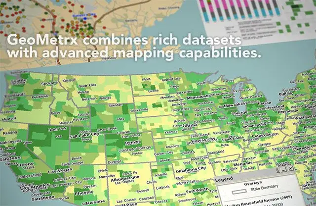
GeoMetrx is a leading provider of online sales and franchise mapping software that lets you take business data from Excel spreadsheets, databases, and enterprise resource planning (ERP) systems and turn it into a visual business intelligence dashboard. It is the leading solution for tracking retail and franchise locations, territories, and sales data.
Over 15,000 businesses use GeoMetrx to quickly and easily track their store and territory locations, sales territories, and sales data, including revenue, unit volumes, item mix, stock levels, and margin. It is designed for small business owners using business intelligence (BI) in Excel and Power BI making it faster and easier to generate reports for tracking business results. Businesses can share data with customers or partners, helping improve collaboration between internal teams or with franchisees or suppliers.


BatchGeo is the world’s largest location cloud services company that offers a simple way to publish maps and data on the web. Today it is used by thousands of companies and millions of people worldwide. The company created a platform for businesses to create interactive maps using their data and content. Users can embed a map on their website or blog via an easy-to-use interface to share with their customers or potential clients.
It is designed for users without any prior mapping experience. BatchGeo is a free and easy-to-use location data management platform that helps businesses create interactive maps and geospatial data visualizations. Every day, users work with a variety of businesses and help them collect, organize, and analyze their location data into actionable insights.

Apple Maps is a handy and reliable mobile app that helps you navigate your world. It updates Apple Maps with new features and information all the time, so you can get from here to there easily and effortlessly. It has an indoor map view (available in select airports, malls, and sports venues), so you can easily find your way around inside major public places. You can now filter directions by transit, walking, or driving to help you decide the best route to take, including estimated travel times.
It quickly finds the closest available parking spot in many locations; just tap on the parking icon in your directions list to view available spots on the Map. With Apple Maps, you can see where the streets are simplified into clear views, and you can get turn-by-turn spoken directions to wherever your iPhone is taking you. You can also search for places like and around the world that have details you need to get where you’re going.

ZeeMaps is a platform that lets you create a map of your world, whether it’s your favorite food cart in Austin or your family’s hometown in India. It works anywhere in the world and on any device because it is powered by open source mapping data, including Mapbox and OpenStreetMap. The user adds the desired address and sees all the places on the Map with a pin. Then he chooses the format in which he wishes to see the results and sees them on the Map. Creating your own maps is easy and fast.
In addition to the classical option, mapping addresses will allow you to create maps from a list of places with their coordinates, give data in the spreadsheet or in sheets, or just with manually selected addresses (you choose). You provide it with an address list or spreadsheet, and it creates a map annotated with these locations. You can add your own placemarks on the Map and label them with individual names. You can add images to the placemarks.
AlignMix is a powerful sales territory mapping solution that allows you to effectively plan, analyze and collaborate on your sales territories. The simple and intuitive interface makes it easy for anyone to create and share sales territory maps, making it perfect for sales managers, sales reps, and field staff. It is a specialized sales territory mapping and analytics solution for the fast-growing world of network marketing and multi-level marketing companies. It enables its users to create on-demand maps of their sales organization and the territories.
The proprietary data science helps some of the biggest brands in the space understand what areas they spend the most time in, how many new customers they have by territory, and how much revenue they are bringing into the business. The company’s main target market is network marketing companies who are interested in boosting their sales through more effective training of their sales reps and more efficient use of their sales force. The company’s mission is to help every network marketer know exactly where they are working and where they need to go to get more customers.
Bing Maps is one of the classical platforms that makes planning a trip easier for customers looking to visit multiple locations. With the new multi-destination feature, users across the U.S. can now plan a trip from a starting point to several stops with up to 20 unique destinations, all directly within Bing Maps. No matter where you’re traveling to, whether it’s for business or pleasure, Bing Maps will get you there.
The main function of this platform includes you can plan trips in advance and see ways to get there on Bing Maps, whether it’s driving, transit, or walking; view live traffic conditions, road closures, and slowdowns on Bing Maps, see aerial imagery, street-level photography, along with satellite views of the entire world, updated several times a day. It lets you search for places and get directions while on the go.

MapMe is a platform that gives a long description of MapMe that enables companies and organizations to leverage maps in order to share their stories, generate more transactions, and improve their customers’ offline experiences. It is a leading provider of mapping map-based commerce software, including indoor maps and mobile applications specifically designed to create and share interactive maps that help companies and organizations to leverage maps to share their stories, generate more transactions, and improve their customers’ experience.
Users simply drag and drop location markers (such as restaurants or stores), add images, text, and videos, and choose from a variety of map styles which make the resulting interactive Map look like a Map or custom marker-less maps. MapMe’s software is used by thousands of organizations from all industries. The current list of the customers includes AMGEN, Autodesk, Boston Children’s Hospital, California Academy of Sciences, Chicago History Museum, Harvard Business School, Kellogg Company, NBA, etc.

Yandex.Maps is a full-featured maps app with voice search, free offline map use, and traffic alerts. It lets you quickly search for addresses, routes, places, and the best places nearby even when you are offline will help you quickly and comfortably find what you need. It shows the approximate time when you need to leave to make it to your meeting in time or the best way to get home if your plans unexpectedly change.
The full-featured offline maps, traffic information, and navigation will help you get around even without internet access. Now you can plan routes, save favorites, find places, and get voice-guided navigation even on an airplane or underground using any part of Free Yandex. Maps or Downloaded Yandex.Maps that are relevant to a particular region. With up-to-date and accurate maps all over the world, it gives you quick access to directions, visual and voice search, and traffic updates.

Mapbox is a map-building platform for developers built to leverage the power of the cloud to make maps for any location-based application. The straightforward and flexible tools have helped people make all kinds of maps, including location analytics dashboards, indoor location-based apps, and bespoke cartography projects. It also enables anyone with a creative passion for designing their own maps in Mapbox Studio and getting hosted data at scale using their API.
Using this, a user can enter their endpoint and multiple stops along their route. If you’re visiting a city and don’t have time to stop in the museum, you can plan a day trip by selecting attractions as stops along your route. You can now build on top of the same high-performance Mapbox GL for your own native mobile apps. Paid sass
Maptitude is a complete geographic analysis and data visualization solution. It combines the functionality of a business intelligence analytical database with the power of advanced spatial analysis tools, enabling you to see spatial relationships and trends in your data in an intuitive environment. The unique tools provide a deeper understanding of the relationships between geography and business performance data. It integrates seamlessly with many enterprise business systems and databases, allowing you to view and analyze your information using an easy-to-use interface.
Maptitude is the creator of Map, the world’s most widely used Microsoft Windows mapping software. The Map is a powerful application that lets you make your own maps, import data to maps, analyze geographic data and connect to business data resources. You can visualize your data in 3D Animations, 2D Maps, and charts. Popular uses include sales territories, election districts, facilities management, land surveying, and utility management.

GPS Visualizer is a free online tool for creating maps and profiles from geographic data in GPX, KML, GeoJSON, and CSV formats. It is designed to be used directly from the browser; no software downloads or installations are needed. You can customize the Map with your own markers and overlays, add lines, points, and polygons to a layer, export the result to Earth to print or save, or share it as a static image. It is a tool for creating maps, profiles, and 3D objects from geographic data. When it comes to geographic data, there is no substitute for maps in explaining where things are and how they relate to each other.
It is a user-friendly web application to create maps and profiles from geographic data. The tool is free, simple to use, seamlessly integrated with GPS Visualizer online service, and can be used to export data in various formats such as KML, GPX, Shapefile, or to visualize it on Maps. The service accepts files in most common GIS formats (e.g., Shapefile, GeoJSON), supports many projection systems. Also, it allows users to upload a file up to 10GB in size.

Maptive is a platform that uses patent-pending technology to take the pain out of creating custom maps by allowing you to easily create your own Map from a spreadsheet, database, or other data source in just two minutes. All you need is your data and your imagination. With this platform, business owners can now create beautiful and successful maps for their customers regardless of location or language. To help users visualize their data more clearly comes with transforming spreadsheet data into a customized Map in seconds.
You can map your data into a customized Map for a variety of purposes, such as: visualizing data from a business-to-business sales pipeline, mapping out the locations of your retail stores, visualizing data from an open source project such as Wikipedia, reporting to your boss exactly which countries you visited on your last business trip, tracking personal projects like home improvement or planning your next vacation and many others. There is a special option for sharing the current location, allowing you to share the present location with any of your clients in no time without any disturbance.

WikiMapia Map is an open-content collaborative mapping project aimed to mark all geographical objects and features from all over the world. The Map simplifies access to information about any location by bringing together data from multiple sources. The main feature of WikiMapia Map is one of the effective platforms that have the ability to edit maps yourself, as well as create new maps. Whatever you want to add to a map or change on it, you can do it right away by clicking “Edit” in the header of that item. You don’t need to be a local resident or an expert geographer. Just register and follow the simple step-by-step process.
The main function of this platform includes adding content to geographic cells, viewing statistical information on content submissions, such as statistics on additions and edits, using basic map editing tools for quick edits and improvements, and many others. Moreover, here users can upload and attach photos to any geographic feature or place tags on top of it. By doing this mapping task, users can earn virtual rewards such as points, achievements, and levels when they are added to the location database and maintained with their contributions.

Scribble Maps is a platform that gives anyone the tools to create and share custom offline maps. It’s a quick and easy way to create maps, even without an account. You can save maps for offline access or make them public to share with others. You can even import a spreadsheet to quickly create a map for your favorite hiking trail, city transit routes, or the location of your favorite taco shop.
Scribble Maps is a quick and easy way to create and share custom maps, even without an account. It’s the only free custom map tool that works entirely in the browser, with no software to download. It’s great for: creating custom maps to display or share, creating a map of a recent vacation, making a map for your home business, creating a map for your kids’ soccer team, showing where you park at work and many others.

ArcGIS Online is a cloud-based geographic information system used to map data, analyze spatial relationships, share and discover geographic information, and visualize geographic patterns. It uses web mapping technologies such as JavaScript, HTML5, and CSS3 to bring geographic data from a variety of sources together into one location.
It is the web mapping platform that thousands of organizations around the world use to publish maps, monitor real-time events, analyze complex data, share information, and much more. To date, more than 11.3 million users have created accounts for ArcGIS Online. It gives you all the tools necessary to build maps, apps, and websites using your own data or many base maps. It’s easy to adapt to your needs, allowing you to use a single subscription for multiple users and projects.

Google Maps API is a free service that lets you embed a map in your website or App and customize its look and feel. Whether you want to show businesses near your customers, add a map to your mobile App, or add directions to a website, then it can help. If your business is open from 9am-5pm Monday-Friday, or 9am-5pm Tuesday-Saturday, you can now specify that on Maps. It is a mapping service from that enables developers to build innovative location-aware applications. Users can view and engage with content on a map or a satellite image of the Earth.
It makes it easy to store and display geographic information, as well as determine a user’s location and for the user to get driving directions between two locations. It can be used in Android development, iOS development, and web development. The Places API allows businesses to get insights from the user community, such as viewing ratings, accessing reviews and getting more information about businesses. It also enables businesses to add places information to their own website.

QGIS is an open-source geographic information system that allows operators to check the geospatial data from various locations and projections with complete visualizations. It includes the major source codes which make it a flexible utility for allowing users to make customized changes to the domain. The users can make the basic settings with detailed editing, vector illustrations, analyzing, and publishing database on Windows, Mac, Linux, BSD, and mobile devices easily.
The users can get deep insights at their available devices due to its lightweight functionality along with the personal desktop, server, in the particular web browser, and as developer, libraries to save and organize the items effectively. The module functions as (GIS) software that helps users integrate the composition and exploration to deploy the graphical maps. The program supports both raster and vector layers where the vector data is stored just like point, line, or polygon features by supporting the multiple formats of raster images.
The basic coding is set with standard plugins written in Python or C++ language, and it integrates with the following servers, such as PostgreSQL, PostGIS, SpatiaLite MySQL databases, PostGIS, GRASS GIS, Google Geocoding API, and several others. QGIS deals with various domains to perform the content shift, including the shapefiles, coverages, personal geodatabases, dxf, MapInfo, PostGIS, and other formats along with web services and external sources.

CityMapper is the best transit app making sophisticated cities easy to use. Data from a large number of famous cities is available in this app. Information about all modes of transportation like subway, ferry, Uber, Bus, and car sharing in those big cities are present on CityMapper. So managing to your trip according to your budget is easy through this app. All transit maps, Real-time departure, Line status and real-time disruption alerts will inform you about updates. CityMapper will combine all possible modes of transport and choose the best option for you to travel. Alternatives are also present to disrupted routes. CityMapper is the Apps of the year for Apple’s 2013 and 2014. Thousands of 5-star user reviews are accessible on CityMapper. CityMapper works with SMS, WhatsApp, Twitter, and Email. You can send your GPS coordinates & map location to anyone through CityMapper.
OpenStreetMap is an open-source web-based application that allows users to easily create and share their walking or cycling routes. This is a perfect application that can be used to plan the routes and travel tracks. This platform provides every single piece of information about the selected route including its elevation from the sea level, the possible fare, fuel consumption, time required to cover that particular area, total distance, and other statistical information which can be used to further reports and results derivation.
This platform also allows the user to integrate its services with other websites and mobile applications including google drive and google maps. The availability of these options makes the saving and sharing of the routing process very simple. This is a free-of-cost service and can be accessed by visiting the official website.

GeoServer is an open-source software service that enables users to share, process, and edit geospatial data. It allows for interoperability between different software, making it a valuable tool for managing and working with geospatial data. It is used by governments, businesses, and individuals all over the world to manage and visualize their data. Some of the features of this platform include the ability to create and edit data, publish data for others to use, and manage multiple datasets.
It is a powerful tool for managing and visualizing geospatial data, and it is free and open source. It enables users to share, process, and edit geospatial data. It has a rich web interface and supports a variety of data formats, including WMS, WFS, and GeoJSON. GeoServer can be used to create dynamic maps and perform spatial analysis.

MapQuest is a one of the fantastic apps because it has different features like Mapping, GPS, Navigation & Traffic. This app will help you live like a local in any area of another country. You can search here nearby points of interest like restaurants, gas, hotels, etc. The user can find his destination faster by using advance research to see contacts, recent searches, top categories and nearby POI. It will simplify your life by finding for you best mode of transportation based on the time of day, weather, and cost. MapQuest will give you information about the rubber-necking and route around accidents so that you can search for alternate routes to your destination. Different transportation options like Uber, car2go, and local transit will help you to get the best choice to move. View here local weather condition to plan the better mode of transportation. If you forget your work, home, and other addresses then bookmark them so you can easily access them from “Go To” on the home screen.
2GIS is map application used for offline mapping and business listening. Trusted information about different restaurants, bar, and hotel are present on this app. It will provide you 3D-maps of more than 180 cities and contacts of over 1.5 million companies including public institutions like hospitals, schools, police stations, etc. This app can access your addresses, phone numbers, e-mail addresses, working hours and payments of these companies. This app will allow you to find the location of the business you are looking for and search out its phone number to make a call. Car routing and searching for public transport routes are available on 2GIS. It will help you to find your exact destination by car or by public transport and identify your location to see what is close to you. After installation of 2GIS, the user can select the city of your need to download the data. Internet connection is not required to operate with directions and maps. The information on this app is updated every month.

Mapline is a great platform for deploying the animate shapes and structures that helps developers and other stakeholders to convert the spreadsheet-based geospatial data into location maps. It is one of the most powerful data management tools that sorts out the diverse demographics and Excel-oriented entries to create unique items. The users can add multiple components into the designs for signifying the three or two-dimensional visualizations with different components, such as heat maps, plan routes, ground areas, hills, boundaries, and other specifications.
Simply paste the valuable data into a format and get fast results without any cumbersome and complex coding expertise. The users may have complete leverage distance analysis and improve the performance reporting by fulfilling the diverse tasks in seconds. Multiple global organizations from different parts of the world have been availing of the plugins and basic tools to provide their customers and followers a complete comprehensive solution.
PostGIS provides effective commands for exchanging the geographic information into complete visualization to set the navigational helping maps with sound graphics quality. It supports the various locations of the PostgreSQL object-relational database by deploying backend spatial specifications (GIS) like ESRI’s SDE or Oracle’s Spatial extension. The program supports the various server integrations for enabling the diverse components to be used as a collective interaction.
There are various additional components and tools available, including basic topology support, data validation, coordinate transformation, programming APIs, and other plugins, etc. The main product development was actually initiated by Refractions Research as a project as an open-source database technology under the GNU General Public License. The module has many packaged installations for operating systems like Windows, Mac, Linux, and the customize settings help build the repositories according to the personalized needs.

Mapbox Studio is an ideal geospatial database management program that helps developers to transform the GIS and other information into complete mapping visualizations with fonts, colors, 3D features, angle projections, and other components. The users can get the basic drawing options just like Photoshop, and make the splendid quality work by setting the images and other illustrations in a well-organized way. The variation in colors helps users change the layers to observe the complete road navigations, landscapes, POI density, typography, and much more.
The programmers may have complete control over the project by arranging the icons, textures, patterns, and other domains in a proper and customized way. The data can be imported or exported from any cloud or module to make choropleths, scaled point maps, and more by following a certain procedure. The cross-device compatibility supports the displays of various domains, such as styles with Mapbox SDKs for iOS, Android, the web, and embedded gadgets without any complex coding.

MapTiler Cloud is a well-integrated navigational program that allows developers to build unique maps by turning the database into smart visualizations like the 3D look, terrain, landscape, greenery, satellite overview, geodata, and a lot of other locational deployments. If you are new to the site and have less expertise in coding domains, then the ideal module is waiting for your creative & innovative skills, so avail the online digital maps for web and mobile programming without any complex coding skills.
It provides the fastest way on the market to serve proper formats to your clients, and all the information is shared instantly with quick processing efficacy. The beautiful shades and graphics quality helps general people understand the addresses and other GIS details comprehensively. The module gets synchronizations with Google and other satellite crawling features to browse the information for setting the basic items easily like streets, paths, roads, and other directions.
SpatiaLite supports the geodatabase functionality that helps developers build customized navigational tools to formulate the maps and directions with well-illustrated specifications. It includes a spatial extension to SQLite along with vector GIS information support which is similar to PostGIS, Oracle Spatial, SQLite/SpatiaLite besides the client-server architecture to deal with common persons easily. The powerful SQL engine is directly embedded within the application to get a complete database simply as an ordinary file that can be freely copied and transferred from one computer or OS to a changed one without any special precaution.
For the implementations of the raw structural settings, the manipulators can set the advanced sequenced queries for supporting the multiple map projections. The program can be integrated with various operating systems to get them working functionality with Linux and Windows as a software library as well as several utilities for arranging the all-in-one interactions. The major components are comprised of line tools that extend SQLite’s own with spatial macros, a graphical GUI for deploying, and a simple desktop GIS tool for browsing data.
Map3 is a secure and fast processing map development platform that provides basic plugins and tools to control the decentralized map network with extremely robust customizations. The users can set the general projections of directory modifications without mighty knowledge of the programming and coding skills. The programmers may have complete control over the project by setting the icons, typography, textures, patterns, and other plugins in a proper and customized style for unique visualizations.
Map3 is free of cost and anyone can start the project easily with the participation of multiple collaborators to deploy the base setup along with minor and major components. With the help of source codes, it will be easy to formulate the global Map3 community where individuals and organizations of all levels can host Map3 nodes and provide useful illustrative content to be distributed on the generalized domain.

MangoMap is an online GIS supportive platform that allows you to create web-oriented maps and navigational tools to cover the geospatial database with effectiveness. It is advanced functionality that is equally beneficial for professionals or inexperienced users to start the project without complex technical assistance. The users can watch the free trial version with complete details and bother about the services and output results with sign up.
It is an ideal domain for deploying the amazing interactive web maps into different projections with fully highlighted special areas like hills, landscapes, terrain, smooth surface, hills, and several other features of the globe. The module provides the quick and lightweight working functionality for converting the spreadsheet-based data into the proper structure and personalizing the experience with a seamless workflow. The platform protects the credentials and sensitive information with 128-bit encryption and other strong safety measures and keeps data in the cloud. The world’s famous information technology organizations have been availing the services and recreating the attractive draws with the help of demographic settings and graphics quality.

Spotzi Mapbuilder is an effective and fast database converting platform that allows developers to create web maps and locational projections by highlighting the special areas and parts. It is a great source for modifying the GIS and physical appearance into visualizations by dragging the data files from the cloud or any other domain. With the help of illustrated specifications, the users may have a complete analysis and estimation of the maps. If you want to explore the customize options, then enter the name of specific items into a default box and get instant results.
The users can complete their work by making the sign-ups via email address and password and have a deep insight into the intuitive dashboard. All the basic structures are integrated with the satellite that helps designers to analyze the overall dimensions and specifications with critical analysis. With the assistance of advanced plugins and components, the users can add customized filters and navigational supports to the existing maps.

Indiemapper is an amazing internet mapping tool that facilitates you building customized locational drawings and patterns by collecting the geospatial database. It is a fast processing module that provides static and thematic assistance from geographic domains to arrange complete functions in the form of unique templates and projections.
The users can get the complete estimation by observing the various colorful impacts, and the common people can easily understand the specific areas with the help of heat maps and shades, as they have to tap the option for shifting the latest significance. There are multiple templates available with the program which can be modified or recreated according to the customized needs.
GeoSHAPE is a flexible repository that allows users to create the geospatial database into a unique map by connecting the information from diverse sources and clouds. It is a great source to modify the plugins and components as the major source codes are available and inexperienced or new users can easily understand as well. It provides great integrations with other clients and hosts where the programmers can set the dimensions according to the cross-devices support and compatibility. The program is embedded with various assisting toolkits, such as GeoNode, Geoserver, GeoGig, Arbiter, and several others to make sure the complete configurations with other components.
The forum has an open environment and policy for all the developers to share their opinion and constructive guidelines for making a better experience for general manipulators. The platform has been allocated as a freemium domain for serving the various social causes, such as security, humanitarian assistance, partner Engagement, and various other non-profitable projects that would ultimately benefit the common people.

Mapotic is a great service for visualizing the crowdsource data where the developers can make unique maps and illustrations by transforming the information into the proper beautiful format with color and other highlighting features. It is an instant digital media protocol that provides effective commands for deploying the backend and easy integration into the existing systems by sorting out the in-range database. It is a SaaS-oriented service that helps organizations and personal users to leverage the overall potential of the raw content with ease.
The particular navigation assistant helps the public sorting out the different destinations comprehensively like wildlife tracking, travel, tourism, IoT telemetry, governance, and others. The users can track the dynamic data and queries easily by connecting people with the same interests to share and exchange knowledge as a reliable user experience. The module has been providing services to multiple businesses and IT institutes and have emerged as a flexible and reliable forum for deploying the location context.

Leaflet is a dynamic map-creating platform that helps programmers to deploy the geodata into comprehensive and beautiful shapes by dragging the details from an open-source JavaScript library. One of the prominent features of the module is the simple usability that enables users to get functionality across various devices and systems. It supports multiple desktop browsers, such as Chrome, Firefox, Safari 5+, Opera 12+, IE 7–11, Edge, and the diverse configuration creates an effective connection with other components.
The users can control the working functionality with basic options, such as keyboard shortcuts, scroll wheel zoom, marker dragging, pan animation, markers, popups, layer switcher, layer, resolution capability, dimensional projection, and several others. The plugins and components can be easily modified as a well-documented API and collaborated with multiple other channels and utilities as a simple and readable functionality for the internal system.

CartoDB is a cloud computing platform that provides spatial databases like GIS, web mapping, location, and other intelligence projections by collecting the various information of digital assets to the main place. The module functions as an open-source software built on PostGIS and PostgreSQL that provides programming assistance by getting the directions with JavaScript as lightweight processing.
For the productivity and increase in the business module, you will have to judge the complete design and supply chain by observing internally or externally the raw database with available portfolios. The users can discover and integrate the cloud-native, on-premise, and hybrid deployments to collaborate with multiple global brands and products. The platform provides the tools with an aptitude for data analysis and visualization to specify the various dimensions and potential of the websites.
Google Maps Engine was a reliable and top-rated choice for the developers to formulate the geospatial database into well-integrated web maps and navigational assistant structures. It was an ideal domain for deploying the amazing interactive templates into different projections with fully highlighted special areas like hills, landscapes, terrain, smooth surface, hills, and several other features of the globe.
The users could ask the questions without any hesitations and make the tools according to the best of available plugins and compatibility for supporting the interfaces and displays. It had kept all the data safe and encrypted that could be fetched any time from strong cloud servers and vice versa. The tool has been discontinued and doesn’t provide the services at the moment, and the users don’t need to worry at all about the credentials and other personal information, as all the queries and items have been deleted systematically.