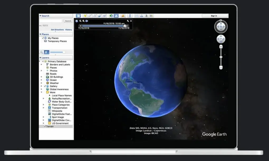
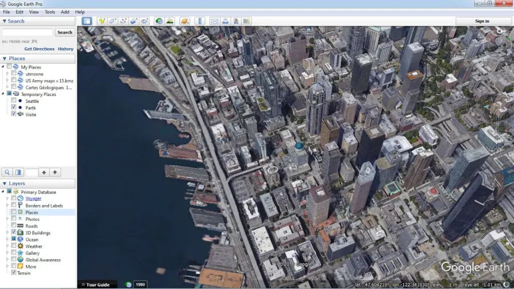
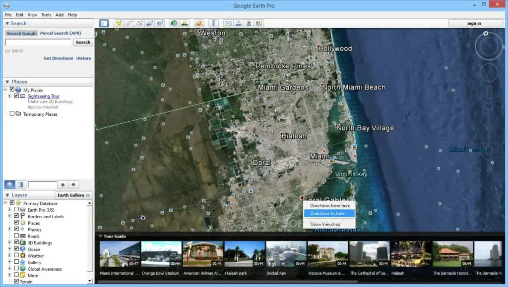
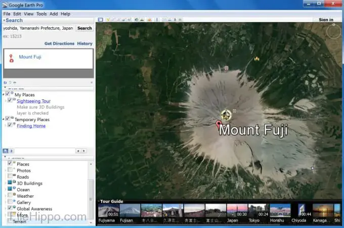
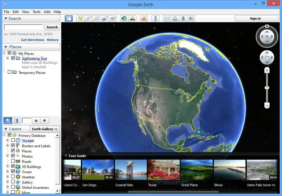
Fly anywhere on the globe with Google Earth Pro to examine satellite pictures, maps, 3D structures, and landscapes, from galaxies in space to underwater canyons. It is a more advanced and professional version of Google Earth that adds a tonne of brand-new features to make it more engaging.
This platform allows you to browse rich geographic content, store locations, and share it with others. If you’ve ever wondered how your neighborhood has evolved over time, Google Earth Pro makes it possible for you to see worldwide changes using decades’ worth of historical imagery.
It checks out how suburban sprawl is melting ice caps, offers you quick access to the past, and does much more. Additional standard capabilities of Google Earth Pro include the ability to track and share your locations, examine 3D buildings, add a soundtrack or narration to the tour, etc.


GitMind is a free online mind mapping tool for task-related brainstorming, project planning, development, and execution. With the help of this tool, you may collaborate and share mind maps with a large number of individuals. The goal of GitMind is to position itself as the top global platform for digital material so that users may do tasks quickly, easily, and with the highest level of productivity possible.

With the help of TrendsMap, you can conveniently and simply monitor Twitter trends around the world. By gathering insights and applying them to marketing campaigns and emotion research, you may take advantage of this data. Both direct observation and keyword searching take place here.

Users of the FindShip program can track ships of all types in the water anywhere in the world. Users can view the precise location of a vessel and follow its movement in real time on a map. The tool can display users up to 100,000 ships and vessels online and covers the majority of ports and seas in the world.
The application gives customers the ability to manage their fleets and offers a variety of information about the ships, including the names of the owner and manager, pictures of the ship, AIS data, and much more. To help sailors navigate, it provides an ETA calculator. Users of FindShip may access weather forecasts for the port as well as typhoon updates and monitoring tools. Users can also let their friends know about their ship. In addition, there is a premium membership option and a free trial.

A sophisticated web-based platform called GPX.studio was created to allow users to edit and create GPX files with the help of online resources. Users of the online web-based software have full control over adding, removing, and deleting points. You also benefit from numerous files combined into a single file. The ability to embed the Map on a website using shareable links and code is very well supported.
For expert mappers to read, produce, edit, and combine GPX files in order to have the correct activity data and to quickly construct beautiful routes, they should use gpx.studio. The best feature of this tool is its capacity to extract segments from traces while still allowing you to carry out other operations. Multiple files can be viewed, traces can be edited, traces can be sped up, timestamps can be added to files, results can be saved on your computer, temperature data can be obtained, and more remarkable features may be added.

Meteoblue is a comprehensive professional weather forecasting service with a lovely, straightforward, and intuitive interface. It provides weather forecasts with lovely animations that easily convey factual information. It displays highly accurate weather forecasts with all the necessary information, including temperature, humidity, wind speed, and directions. More significantly, if a tragedy has occurred, it gives you full facts from all around the world.
It includes the Meta-predictions, which are based on analyzing specific time periods of recent data in order to make accurate forecasts of the future. You have the power to view a detailed seven to fourteen-day weather forecast. so that you may appropriately organize your holiday. By enabling users to investigate climate changes in any location, Meteoblue is revolutionizing itself.
However, it boasts a distinctive home screen that offers users the knowledge they require at a glance. Additionally, there is the advanced search functionality, so if you want to locate the prediction for your city, just key in the location, and Meteoblue will undoubtedly offer correct information.

Move to measure – Flying Ruler is a multiple objects’ positions calculating program that provides effective and smooth leveling, projections, and angles checking tools to estimate exact and straight lengths & widths. Flying Ruler is an application that turns your iPhone into a ruler and allows you to measure anything you want with your iPhone or iPad. You can measure the distance between any two objects just by moving your iPhone in front of them.
It’s a simple and accurate way to measure distance, and you need just drag out the line and move to where you want to measure. The ruler calculates the distance and displays the value in metric units or imperial units on top of the screen. The program is a simple and useful tool you can use to make your daily work faster. This ruler tool by drawing a line on the screen of your device can easily calculate the length of the side of a rectangle.

GPS Visualizer is a free online tool for creating maps and profiles from geographic data in GPX, KML, GeoJSON, and CSV formats. It is designed to be used directly from the browser; no software downloads or installations are needed. You can customize the Map with your own markers and overlays, add lines, points, and polygons to a layer, export the result to Earth to print or save, or share it as a static image. It is a tool for creating maps, profiles, and 3D objects from geographic data. When it comes to geographic data, there is no substitute for maps in explaining where things are and how they relate to each other.
It is a user-friendly web application to create maps and profiles from geographic data. The tool is free, simple to use, seamlessly integrated with GPS Visualizer online service, and can be used to export data in various formats such as KML, GPX, Shapefile, or to visualize it on Maps. The service accepts files in most common GIS formats (e.g., Shapefile, GeoJSON), supports many projection systems. Also, it allows users to upload a file up to 10GB in size.

Mapbox is a map-building platform for developers built to leverage the power of the cloud to make maps for any location-based application. The straightforward and flexible tools have helped people make all kinds of maps, including location analytics dashboards, indoor location-based apps, and bespoke cartography projects. It also enables anyone with a creative passion for designing their own maps in Mapbox Studio and getting hosted data at scale using their API.
Using this, a user can enter their endpoint and multiple stops along their route. If you’re visiting a city and don’t have time to stop in the museum, you can plan a day trip by selecting attractions as stops along your route. You can now build on top of the same high-performance Mapbox GL for your own native mobile apps. Paid sass

WikiMapia Map is an open-content collaborative mapping project aimed to mark all geographical objects and features from all over the world. The Map simplifies access to information about any location by bringing together data from multiple sources. The main feature of WikiMapia Map is one of the effective platforms that have the ability to edit maps yourself, as well as create new maps. Whatever you want to add to a map or change on it, you can do it right away by clicking “Edit” in the header of that item. You don’t need to be a local resident or an expert geographer. Just register and follow the simple step-by-step process.
The main function of this platform includes adding content to geographic cells, viewing statistical information on content submissions, such as statistics on additions and edits, using basic map editing tools for quick edits and improvements, and many others. Moreover, here users can upload and attach photos to any geographic feature or place tags on top of it. By doing this mapping task, users can earn virtual rewards such as points, achievements, and levels when they are added to the location database and maintained with their contributions.
Google Maps API is a free service that lets you embed a map in your website or App and customize its look and feel. Whether you want to show businesses near your customers, add a map to your mobile App, or add directions to a website, then it can help. If your business is open from 9am-5pm Monday-Friday, or 9am-5pm Tuesday-Saturday, you can now specify that on Maps. It is a mapping service from that enables developers to build innovative location-aware applications. Users can view and engage with content on a map or a satellite image of the Earth.
It makes it easy to store and display geographic information, as well as determine a user’s location and for the user to get driving directions between two locations. It can be used in Android development, iOS development, and web development. The Places API allows businesses to get insights from the user community, such as viewing ratings, accessing reviews and getting more information about businesses. It also enables businesses to add places information to their own website.
AlignMix is a powerful sales territory mapping solution that allows you to effectively plan, analyze and collaborate on your sales territories. The simple and intuitive interface makes it easy for anyone to create and share sales territory maps, making it perfect for sales managers, sales reps, and field staff. It is a specialized sales territory mapping and analytics solution for the fast-growing world of network marketing and multi-level marketing companies. It enables its users to create on-demand maps of their sales organization and the territories.
The proprietary data science helps some of the biggest brands in the space understand what areas they spend the most time in, how many new customers they have by territory, and how much revenue they are bringing into the business. The company’s main target market is network marketing companies who are interested in boosting their sales through more effective training of their sales reps and more efficient use of their sales force. The company’s mission is to help every network marketer know exactly where they are working and where they need to go to get more customers.

Angle Meter 360 is a perfect app when someone is trying to get an angle from below or above positions of various objects like pics and other physical items. It can take amazing photographs, but sometimes getting the best angle is as tricky as taking the photo, to begin with. Whether you’re taking the perfect shot of a flower, or trying to capture your pals on the slopes, it will help you find just the right angle. Just point your phone in any direction and it’ll show you what lies ahead in a 3D look.
Now, maybe you don’t need to see exactly what’s around that corner, all the projection is completed by the automated algorithms. The app is a simple and useful tool to measure the angle with your iPhone, Android, iPad, or iPod touch. It is widely used by painters and decorators, photographers, and other people who need to measure the angle quickly. It is one of the most popular version apps for measuring angles for using in different formulas, such as interior design, carpentry, construction, decoration, photography, and video.

ZeeMaps is a platform that lets you create a map of your world, whether it’s your favorite food cart in Austin or your family’s hometown in India. It works anywhere in the world and on any device because it is powered by open source mapping data, including Mapbox and OpenStreetMap. The user adds the desired address and sees all the places on the Map with a pin. Then he chooses the format in which he wishes to see the results and sees them on the Map. Creating your own maps is easy and fast.
In addition to the classical option, mapping addresses will allow you to create maps from a list of places with their coordinates, give data in the spreadsheet or in sheets, or just with manually selected addresses (you choose). You provide it with an address list or spreadsheet, and it creates a map annotated with these locations. You can add your own placemarks on the Map and label them with individual names. You can add images to the placemarks.

BatchGeo is the world’s largest location cloud services company that offers a simple way to publish maps and data on the web. Today it is used by thousands of companies and millions of people worldwide. The company created a platform for businesses to create interactive maps using their data and content. Users can embed a map on their website or blog via an easy-to-use interface to share with their customers or potential clients.
It is designed for users without any prior mapping experience. BatchGeo is a free and easy-to-use location data management platform that helps businesses create interactive maps and geospatial data visualizations. Every day, users work with a variety of businesses and help them collect, organize, and analyze their location data into actionable insights.
Maptitude is a complete geographic analysis and data visualization solution. It combines the functionality of a business intelligence analytical database with the power of advanced spatial analysis tools, enabling you to see spatial relationships and trends in your data in an intuitive environment. The unique tools provide a deeper understanding of the relationships between geography and business performance data. It integrates seamlessly with many enterprise business systems and databases, allowing you to view and analyze your information using an easy-to-use interface.
Maptitude is the creator of Map, the world’s most widely used Microsoft Windows mapping software. The Map is a powerful application that lets you make your own maps, import data to maps, analyze geographic data and connect to business data resources. You can visualize your data in 3D Animations, 2D Maps, and charts. Popular uses include sales territories, election districts, facilities management, land surveying, and utility management.

Maptive is a platform that uses patent-pending technology to take the pain out of creating custom maps by allowing you to easily create your own Map from a spreadsheet, database, or other data source in just two minutes. All you need is your data and your imagination. With this platform, business owners can now create beautiful and successful maps for their customers regardless of location or language. To help users visualize their data more clearly comes with transforming spreadsheet data into a customized Map in seconds.
You can map your data into a customized Map for a variety of purposes, such as: visualizing data from a business-to-business sales pipeline, mapping out the locations of your retail stores, visualizing data from an open source project such as Wikipedia, reporting to your boss exactly which countries you visited on your last business trip, tracking personal projects like home improvement or planning your next vacation and many others. There is a special option for sharing the current location, allowing you to share the present location with any of your clients in no time without any disturbance.
Protractor+ is a simple & versatile measuring tool that takes the angle of the object and provides an accurate angle measurement just like the geometrical protractor tool. It is the quality-providing tool that allows you to measure and check angles in landscape and portrait modes on your mobile phone. Create accurate, professional-quality sketches on your mobile devices easily through complete comprehension of scales and stats.
It is the perfect tool for designers, illustrators, and anyone who wants to take their sketching skills to the next level. It allows users to calibrate a protractor to their device without having to send their device off to a lab. The program can be used to calibrate any type of touch screen protractor to any smartphone or tablet. A user can then use the protractor to measure angles on their device screen and export the results for analysis.
Bing Maps is one of the classical platforms that makes planning a trip easier for customers looking to visit multiple locations. With the new multi-destination feature, users across the U.S. can now plan a trip from a starting point to several stops with up to 20 unique destinations, all directly within Bing Maps. No matter where you’re traveling to, whether it’s for business or pleasure, Bing Maps will get you there.
The main function of this platform includes you can plan trips in advance and see ways to get there on Bing Maps, whether it’s driving, transit, or walking; view live traffic conditions, road closures, and slowdowns on Bing Maps, see aerial imagery, street-level photography, along with satellite views of the entire world, updated several times a day. It lets you search for places and get directions while on the go.

MapMe is a platform that gives a long description of MapMe that enables companies and organizations to leverage maps in order to share their stories, generate more transactions, and improve their customers’ offline experiences. It is a leading provider of mapping map-based commerce software, including indoor maps and mobile applications specifically designed to create and share interactive maps that help companies and organizations to leverage maps to share their stories, generate more transactions, and improve their customers’ experience.
Users simply drag and drop location markers (such as restaurants or stores), add images, text, and videos, and choose from a variety of map styles which make the resulting interactive Map look like a Map or custom marker-less maps. MapMe’s software is used by thousands of organizations from all industries. The current list of the customers includes AMGEN, Autodesk, Boston Children’s Hospital, California Academy of Sciences, Chicago History Museum, Harvard Business School, Kellogg Company, NBA, etc.

Scribble Maps is a platform that gives anyone the tools to create and share custom offline maps. It’s a quick and easy way to create maps, even without an account. You can save maps for offline access or make them public to share with others. You can even import a spreadsheet to quickly create a map for your favorite hiking trail, city transit routes, or the location of your favorite taco shop.
Scribble Maps is a quick and easy way to create and share custom maps, even without an account. It’s the only free custom map tool that works entirely in the browser, with no software to download. It’s great for: creating custom maps to display or share, creating a map of a recent vacation, making a map for your home business, creating a map for your kids’ soccer team, showing where you park at work and many others.
Yandex.Maps is a full-featured maps app with voice search, free offline map use, and traffic alerts. It lets you quickly search for addresses, routes, places, and the best places nearby even when you are offline will help you quickly and comfortably find what you need. It shows the approximate time when you need to leave to make it to your meeting in time or the best way to get home if your plans unexpectedly change.
The full-featured offline maps, traffic information, and navigation will help you get around even without internet access. Now you can plan routes, save favorites, find places, and get voice-guided navigation even on an airplane or underground using any part of Free Yandex. Maps or Downloaded Yandex.Maps that are relevant to a particular region. With up-to-date and accurate maps all over the world, it gives you quick access to directions, visual and voice search, and traffic updates.

Angle Pro is a simple yet powerful angle meter and level app designed specifically to help you get things level and plumb with complete angles insights. The default level on your phone is a very crude instrument that provides accurate and effective results with different color schemes. With the app, you can set up extremely accurate measurements. Measure distances, angles, and levels quickly and easily thanks to the high precision inclinometer and level.
The app is designed to make it easy to do precise incline and decline measurements. The bubble level allows you to measure angle gradients accurately by placing the level bubble onto the screen and aligning it to your device’s digital bubble level. You can then check that it is aligned by viewing the cross in the middle of your screen. This advanced angle meter app is far more than just a simple protractor that provides real-time parallax correction and advanced features that are often found in high-end SLR cameras.

Camera Protractor is a valuable tool that enables users to check the photos and other objects presented in an image with different projections like length, width, angles, or other dimensions. Taking great photos is one of those things that rarely comes naturally. No matter how much you practice and research, you’re always left wondering whether you could have done better. Snaps are making it easy for anyone to take photos that look good every time with complete calculations of angles and measurements.
Using the protractor tool inside Snaps, simply place your phone at the angle you’d like to use and it’ll guide you through each step of taking a picture that’s incredibly easy to use and extremely useful. There are some valuable tasks, such as snapping’ the angle with your device’s camera, calculating the angle you snapped (in either degree or radian), displaying this angle alongside a protractor, and others.

GeoMetrx is a leading provider of online sales and franchise mapping software that lets you take business data from Excel spreadsheets, databases, and enterprise resource planning (ERP) systems and turn it into a visual business intelligence dashboard. It is the leading solution for tracking retail and franchise locations, territories, and sales data.
Over 15,000 businesses use GeoMetrx to quickly and easily track their store and territory locations, sales territories, and sales data, including revenue, unit volumes, item mix, stock levels, and margin. It is designed for small business owners using business intelligence (BI) in Excel and Power BI making it faster and easier to generate reports for tracking business results. Businesses can share data with customers or partners, helping improve collaboration between internal teams or with franchisees or suppliers.