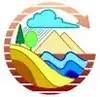
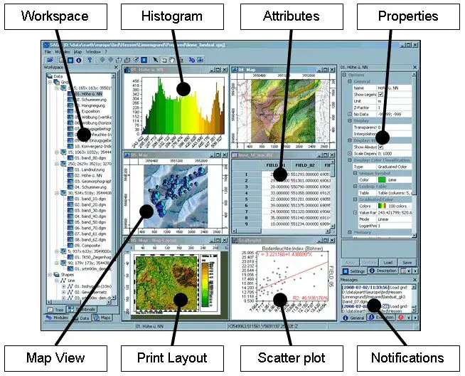
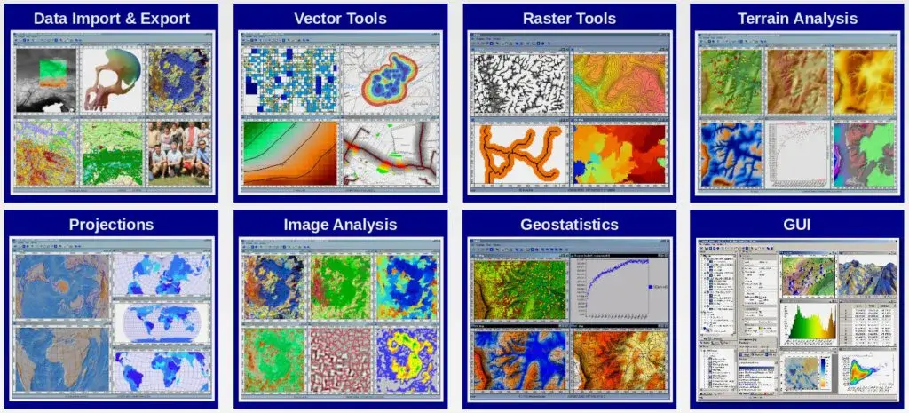
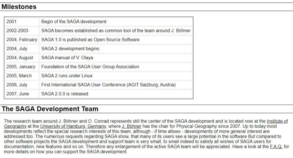
SAGA GIS is a German company that specializes in automated geoscientific analyses. Their software is used to create maps and models of the earth’s surface, and their products are relied on by researchers and businesses all over the world. It is especially notable for its ability to handle huge amounts of data quickly and efficiently, making it an invaluable tool for projects that need to be completed quickly and accurately. It is a software system that provides a broad range of geoscientific analyses.
It offers a collection of powerful tools that allow you to work with digital data in a sophisticated way. With this platform, you can create, edit, analyze, visualize and publish digital maps. The program offers a wide range of functions, including data management, spatial analysis, map making, and 3D visualization. In addition, SAGA GIS also allows you to import and export data in various formats. The system works with various data types, including raster, vector, and point cloud data.
The software is used by researchers, students, and professionals in a variety of fields, including geography, archaeology, forestry, land management, and environmental science. It is a comprehensive software for automated geoscientific analyses. It offers a wide range of modules for data preparation, visualization, statistical analysis, geo-statistics, and 3D modeling. SAGA GIS is used by many research institutes, universities, and companies all over the world.


GeoServer is an open-source software service that enables users to share, process, and edit geospatial data. It allows for interoperability between different software, making it a valuable tool for managing and working with geospatial data. It is used by governments, businesses, and individuals all over the world to manage and visualize their data. Some of the features of this platform include the ability to create and edit data, publish data for others to use, and manage multiple datasets.
It is a powerful tool for managing and visualizing geospatial data, and it is free and open source. It enables users to share, process, and edit geospatial data. It has a rich web interface and supports a variety of data formats, including WMS, WFS, and GeoJSON. GeoServer can be used to create dynamic maps and perform spatial analysis.
Mapserver is free and open-source software that enables users to display dynamic spatial maps over the Internet. With this platform, users can easily create and manage spatial data, as well as customize their maps to meet specific needs. Additionally, it is highly scalable and can handle large amounts of data quickly and efficiently. With this, you can easily display your location data on a map and make your maps available to the public.
Mapserver is an open-source software application that enables users to display dynamic spatial maps over the Internet. It is a popular choice for web mapping, as it allows for the customization of maps to meet the specific needs of users. Additionally, it is often used in conjunction with Geographic Information Systems (GIS) software.

OpenGeo Suite is a full geospatial software stack. It includes all the software needed to create and manage spatial data, build maps and perform geospatial analysis. It is composed of the Core, which provides the fundamental functionality, and a growing number of extensions that provide additional features and capabilities. It is used by organizations of all sizes, from small businesses to global enterprises, in a wide variety of industries. It is a full geospatial software stack that provides developers with the tools they need to build complete spatial applications.
It is comprised of a number of individual components, including the OpenGeo Portal, the OpenGeo Framework, the OpenGeo Spreadsheet, the OpenGeo Maps, and the OpenGeo Library. The OpenGeo Suite is available in both open-source and commercial editions, and it can be deployed on-premises or in the cloud. It provides the backbone for geospatial operations and also includes a suite of desktop applications, including OpenGeo Framework for developing custom applications, OpenGeo Viewer for creating and sharing visualizations, and OpenGeo Tools for managing and manipulating geospatial data.

GeoNode is a web application that helps you develop your geospatial information systems (GIS). It allows you to create and manage spatial data, share your data with others, and build applications that use spatial data. It is open-source software released under the GPL License. It is an open-source platform for developing geospatial information systems (GIS) and allows you to create and share maps, geospatial data, and applications.
The GeoNode community has created a wide variety of features and plugins that allow you to do everything from creating simple maps to developing sophisticated GIS applications. It is also part of the larger GeoWeb community, which includes projects such as GeoServer, uDig, QGIS, and PostGIS. It enables you to create and share maps, manage data, and perform analysis. It is built on top of the PostGIS spatial database and Mapnik vector rendering engine.

NextBillion.ai is a mapping and geospatial platform that provides NGOs, social enterprises, and development practitioners with the tools they need to make informed data-driven decisions. Using this platform, users can map projects, track program progress, measure results, and more. The platform is designed to make it easy for users to collect and visualize data from a variety of sources, including surveys, satellite imagery, and local data. It offers a range of features for data analysis and visualizations, making it possible to quickly spot trends and patterns in data. It helps businesses and organizations make better decisions by providing them with location-based insights.
With NextBillion.ai, businesses can visualize data on a map and better understand how their operations are related to their surrounding environment. It offers tools for data collection, analysis, and sharing, making it an ideal platform for businesses and organizations of all sizes. You can quickly create maps and analyze data to find trends, make comparisons, and discover opportunities. NextBillion.ai is the perfect tool for businesses and governments that need to make decisions based on location data.

ESRI Geoportal Server provides access to geospatial resources, including datasets, rasters, and Web services. It makes it easy for you to find and use the geospatial resources you need. The Geoportal Server includes powerful search and discovery capabilities, so you can find the resources you need quickly and easily. You can also browse by topic, publisher, or resource type. It is based on the ArcGIS platform, so it integrates with ArcGIS software and services.
The server makes it easy for you to find, preview, and download the geospatial resources you need. You can also use the server to create custom Web services that meet your specific needs. It enables the discovery and use of geospatial resources, including datasets, rasters, and Web services. It provides a searchable catalog of these resources, making it easy to find what you need. The Geoportal Server also allows you to publish your own geospatial resources so that they can be discovered and used by others.

Mapnik is an open-source toolkit for developing mapping applications. It provides powerful raster and vector rendering, a well-designed style system, and easy-to-use APIs for Python, C++, and Node.js. It provides a rendering engine with high performance and a sophisticated feature set, as well as a comprehensive suite of tools for managing data sources and preparing map data for rendering. It offers powerful rendering and editing features while also maintaining a high degree of compatibility with standard raster formats.
Mapnik was designed with two primary goals in mind: to make it easy for developers to create beautiful maps and to ensure that maps remain accessible to users regardless of their level of technical expertise. It provides a wide range of features, including support for advanced rendering features such as transparency and blends modes, on-the-fly rendering of labels and annotations, and dynamic styling of features based on their attributes. In addition to its rendering capabilities, it also offers a comprehensive set of editing features, allowing developers to easily modify the geometry, attribution, and styling of their maps.

OpenJUMP GIS is open-source software for editing, viewing, and analyzing spatial data. It lets you create and edit spatial data in a variety of formats, including shapefiles, GeoJSON, and PostGIS. It supports viewing data in a variety of projections and can export data to SVG, PDF, KML, and other formats. It can also import data from a variety of sources, including GPS devices. It is a fairly mature project with a large user base. It is actively developed, with new features and bug fixes appearing frequently.
It is well-supported by a community of developers and users. The software means you can freely use, copy, distribute and study it. It is intended to provide a wide range of features and functions to allow users to manipulate, view, analyze and publish spatial data. It has been developed with the aim of providing an easy-to-use platform for students, teachers, researchers, and developers.

uDig is an open-source geospatial information platform that enables users to author, share, and use spatial information in innovative ways. With this platform, users can create and edit spatial data, build custom mapping applications, and connect with others in the spatial community. It is built on the Java platform and is released under the GNU Lesser General Public License. It enables users to easily create, edit, visualize and share spatial data. It is designed for use in both desktop and web-based environments and can be deployed on a variety of operating systems.
uDig provides a simple, easy-to-use interface for creating and working with spatial data. It features a powerful engine for editing and transforming data, as well as advanced visualization capabilities. It includes a comprehensive set of tools for data sharing, allowing users to easily publish spatial data to the web or export it for use in other applications. It is designed for use by developers and cartographers but can also be used by anyone who wants to get a better understanding of their geographic surroundings.

Geoclip is an interactive maps and data visualization company. It makes it easy for you to explore, analyze and share geospatial data. The products are used by businesses, educators, and governments all over the world. It believes that maps and data should be easy to use and accessible to everyone. That’s why it makes products available online, on mobile devices, and in print. It offers a range of services to help you get the most out of your data. The products are used by businesses, educators, and governments all over the world.
It has a team of experts who can help you get the most out of your data and offer a range of services to help you get started. With this platform, you can quickly create maps that show your data in ways never before possible and understand the power of spatial data; maps are not only beautiful but also highly informative. Whether you need to show the location of your business, visualize sales data, or track customer engagement, Geoclip has you covered. It offers a wide range of features, from simple point-and-click mapping to sophisticated data analysis and visualization.

Maplarge is a data analytics and visualization company. It helps businesses make data-driven decisions by providing them with actionable insights from their data which allows businesses to easily create and share interactive visualizations. The platform is built on top of the latest data technologies, which allows you to provide users with the most accurate and up-to-date insights. It is all about data analytics and visualization.
The technology allows you to quickly create maps and charts that help you see patterns and trends. It works with a variety of clients, from large corporations to small businesses. It has a team of experts who can help you with everything from data analysis to map design and also have a free trial so that you can try out technology yourself. With MapLarge, you can quickly see the big picture and make informed decisions. Whether you’re looking to track customer behavior, measure marketing performance, or investigate financial trends, it has the tools you need to get the insights you need.

GeniusGIS is a mapping application that helps you find the perfect location for your business. With this platform, you can easily and quickly find information about potential customers in your area, as well as the best places to set up shop. It makes it easy for you to find the right location for your business, so you can focus on what you do best. It is a mapping application that helps businesses and individuals find the best location for their needs.
Whether you’re looking for a new office retail space or just want to know more about your community, GeniusGIS can help. With an easy-to-use interface and detailed maps, you’ll be able to find the perfect spot in no time. With this, you can easily view detailed maps of any area in the world and find information about businesses and other points of interest in that area.

GRASS GIS is a powerful and versatile open-source Geographic Information System (GIS) with raster and vector processing capabilities. It is a major component of the free software geographic information system (GIS) suite, QGIS. It is used by government agencies, universities, and companies around the world for managing and analyzing spatial data, such as land use and land cover, environmental impact assessments, disaster management, cartography, and remote sensing.
It is a powerful tool for managing and analyzing geospatial data. It can be used for managing and creating maps, managing and analyzing satellite imagery, conducting land surveys, and more. GRASS GIS is related to geospatial data management and analysis, image processing, graphics/maps.

gvSIG Desktop is a comprehensive software solution for capturing, storing, handling, analyzing, and deploying any kind of referenced geographic information. It offers a wide range of features and functionality and can be used by both professional users and those with little or no prior experience in GIS. It is based on the open-source gvSIG software, which is maintained and developed by the gvSIG Association. The desktop version has been specifically designed for desktop use and offers a more user-friendly interface and a wider range of features than the web version.
It is available in two versions: a free Community Edition and a paid Professional Edition. The Community Edition offers all the functionality of the Professional Edition but is limited to a maximum of 500 features. The Professional Edition has no such limit and also includes support from the gvSIG Association. The gvSIG Desktop is a powerful and user-friendly desktop software for managing and processing geographic information.
It is a great tool for capturing, storing, handling, analyzing, and deploying any kind of referenced geographic information, including maps, aerial photos, land registry data, points of interest, etc. It captures, stores, handles, analyzes, and deploys any kind of referenced geographic information. It provides all the necessary tools for managing geographical data of any type and size.

Nearmap is an Australian aerial mapping company that provides high-resolution aerial maps and 3D maps. The high-resolution aerial maps provide business and government organizations with accurate, up-to-date images of their surroundings. The company’s 3D maps provide a rich, interactive experience that allows users to navigate their environment and view it from any angle. The solutions are used by a wide range of organizations, including businesses, government agencies, and non-profit organizations.
Nearmap is the leading provider of high-resolution aerial maps and 3D maps for business and government. The easy-to-use tools make it simple to get up-to-date information about any location from any device. With this platform, you can quickly and easily get accurate, real-time data about your surroundings to make better, more informed decisions. It is a provider of high-resolution aerial maps and 3D maps. The images are updated weekly and are sharper, clearer, and more up-to-date than any other map provider. It is used by businesses all over the world to improve their operations, make better decisions, and increase their efficiency.

Alta4 is a web-based GIS software that helps businesses make better decisions with spatial data. With easy-to-use tools, you can collect data, analyze it, and share your results with others quickly and easily. It is perfect for businesses of all sizes, and we offer a variety of plans to fit your needs. It is the leading web-based GIS software, providing solutions for asset management, land management, and public safety.
The team of experts has over 100 years of combined experience in GIS, software development, and data management, making Alta4 the best choice for your GIS needs. It makes it easy for you to collect and analyze data, no matter where you are or what device you’re using. With software, you can access your maps and data anytime, anywhere.
SpatiaLite supports the geodatabase functionality that helps developers build customized navigational tools to formulate the maps and directions with well-illustrated specifications. It includes a spatial extension to SQLite along with vector GIS information support which is similar to PostGIS, Oracle Spatial, SQLite/SpatiaLite besides the client-server architecture to deal with common persons easily. The powerful SQL engine is directly embedded within the application to get a complete database simply as an ordinary file that can be freely copied and transferred from one computer or OS to a changed one without any special precaution.
For the implementations of the raw structural settings, the manipulators can set the advanced sequenced queries for supporting the multiple map projections. The program can be integrated with various operating systems to get them working functionality with Linux and Windows as a software library as well as several utilities for arranging the all-in-one interactions. The major components are comprised of line tools that extend SQLite’s own with spatial macros, a graphical GUI for deploying, and a simple desktop GIS tool for browsing data.

QGIS is an open-source geographic information system that allows operators to check the geospatial data from various locations and projections with complete visualizations. It includes the major source codes which make it a flexible utility for allowing users to make customized changes to the domain. The users can make the basic settings with detailed editing, vector illustrations, analyzing, and publishing database on Windows, Mac, Linux, BSD, and mobile devices easily.
The users can get deep insights at their available devices due to its lightweight functionality along with the personal desktop, server, in the particular web browser, and as developer, libraries to save and organize the items effectively. The module functions as (GIS) software that helps users integrate the composition and exploration to deploy the graphical maps. The program supports both raster and vector layers where the vector data is stored just like point, line, or polygon features by supporting the multiple formats of raster images.
The basic coding is set with standard plugins written in Python or C++ language, and it integrates with the following servers, such as PostgreSQL, PostGIS, SpatiaLite MySQL databases, PostGIS, GRASS GIS, Google Geocoding API, and several others. QGIS deals with various domains to perform the content shift, including the shapefiles, coverages, personal geodatabases, dxf, MapInfo, PostGIS, and other formats along with web services and external sources.

Mapbox Studio is an ideal geospatial database management program that helps developers to transform the GIS and other information into complete mapping visualizations with fonts, colors, 3D features, angle projections, and other components. The users can get the basic drawing options just like Photoshop, and make the splendid quality work by setting the images and other illustrations in a well-organized way. The variation in colors helps users change the layers to observe the complete road navigations, landscapes, POI density, typography, and much more.
The programmers may have complete control over the project by arranging the icons, textures, patterns, and other domains in a proper and customized way. The data can be imported or exported from any cloud or module to make choropleths, scaled point maps, and more by following a certain procedure. The cross-device compatibility supports the displays of various domains, such as styles with Mapbox SDKs for iOS, Android, the web, and embedded gadgets without any complex coding.

MapTiler Cloud is a well-integrated navigational program that allows developers to build unique maps by turning the database into smart visualizations like the 3D look, terrain, landscape, greenery, satellite overview, geodata, and a lot of other locational deployments. If you are new to the site and have less expertise in coding domains, then the ideal module is waiting for your creative & innovative skills, so avail the online digital maps for web and mobile programming without any complex coding skills.
It provides the fastest way on the market to serve proper formats to your clients, and all the information is shared instantly with quick processing efficacy. The beautiful shades and graphics quality helps general people understand the addresses and other GIS details comprehensively. The module gets synchronizations with Google and other satellite crawling features to browse the information for setting the basic items easily like streets, paths, roads, and other directions.
PostGIS provides effective commands for exchanging the geographic information into complete visualization to set the navigational helping maps with sound graphics quality. It supports the various locations of the PostgreSQL object-relational database by deploying backend spatial specifications (GIS) like ESRI’s SDE or Oracle’s Spatial extension. The program supports the various server integrations for enabling the diverse components to be used as a collective interaction.
There are various additional components and tools available, including basic topology support, data validation, coordinate transformation, programming APIs, and other plugins, etc. The main product development was actually initiated by Refractions Research as a project as an open-source database technology under the GNU General Public License. The module has many packaged installations for operating systems like Windows, Mac, Linux, and the customize settings help build the repositories according to the personalized needs.
Map3 is a secure and fast processing map development platform that provides basic plugins and tools to control the decentralized map network with extremely robust customizations. The users can set the general projections of directory modifications without mighty knowledge of the programming and coding skills. The programmers may have complete control over the project by setting the icons, typography, textures, patterns, and other plugins in a proper and customized style for unique visualizations.
Map3 is free of cost and anyone can start the project easily with the participation of multiple collaborators to deploy the base setup along with minor and major components. With the help of source codes, it will be easy to formulate the global Map3 community where individuals and organizations of all levels can host Map3 nodes and provide useful illustrative content to be distributed on the generalized domain.

MangoMap is an online GIS supportive platform that allows you to create web-oriented maps and navigational tools to cover the geospatial database with effectiveness. It is advanced functionality that is equally beneficial for professionals or inexperienced users to start the project without complex technical assistance. The users can watch the free trial version with complete details and bother about the services and output results with sign up.
It is an ideal domain for deploying the amazing interactive web maps into different projections with fully highlighted special areas like hills, landscapes, terrain, smooth surface, hills, and several other features of the globe. The module provides the quick and lightweight working functionality for converting the spreadsheet-based data into the proper structure and personalizing the experience with a seamless workflow. The platform protects the credentials and sensitive information with 128-bit encryption and other strong safety measures and keeps data in the cloud. The world’s famous information technology organizations have been availing the services and recreating the attractive draws with the help of demographic settings and graphics quality.

Mapline is a great platform for deploying the animate shapes and structures that helps developers and other stakeholders to convert the spreadsheet-based geospatial data into location maps. It is one of the most powerful data management tools that sorts out the diverse demographics and Excel-oriented entries to create unique items. The users can add multiple components into the designs for signifying the three or two-dimensional visualizations with different components, such as heat maps, plan routes, ground areas, hills, boundaries, and other specifications.
Simply paste the valuable data into a format and get fast results without any cumbersome and complex coding expertise. The users may have complete leverage distance analysis and improve the performance reporting by fulfilling the diverse tasks in seconds. Multiple global organizations from different parts of the world have been availing of the plugins and basic tools to provide their customers and followers a complete comprehensive solution.

Spotzi Mapbuilder is an effective and fast database converting platform that allows developers to create web maps and locational projections by highlighting the special areas and parts. It is a great source for modifying the GIS and physical appearance into visualizations by dragging the data files from the cloud or any other domain. With the help of illustrated specifications, the users may have a complete analysis and estimation of the maps. If you want to explore the customize options, then enter the name of specific items into a default box and get instant results.
The users can complete their work by making the sign-ups via email address and password and have a deep insight into the intuitive dashboard. All the basic structures are integrated with the satellite that helps designers to analyze the overall dimensions and specifications with critical analysis. With the assistance of advanced plugins and components, the users can add customized filters and navigational supports to the existing maps.

Indiemapper is an amazing internet mapping tool that facilitates you building customized locational drawings and patterns by collecting the geospatial database. It is a fast processing module that provides static and thematic assistance from geographic domains to arrange complete functions in the form of unique templates and projections.
The users can get the complete estimation by observing the various colorful impacts, and the common people can easily understand the specific areas with the help of heat maps and shades, as they have to tap the option for shifting the latest significance. There are multiple templates available with the program which can be modified or recreated according to the customized needs.
GeoSHAPE is a flexible repository that allows users to create the geospatial database into a unique map by connecting the information from diverse sources and clouds. It is a great source to modify the plugins and components as the major source codes are available and inexperienced or new users can easily understand as well. It provides great integrations with other clients and hosts where the programmers can set the dimensions according to the cross-devices support and compatibility. The program is embedded with various assisting toolkits, such as GeoNode, Geoserver, GeoGig, Arbiter, and several others to make sure the complete configurations with other components.
The forum has an open environment and policy for all the developers to share their opinion and constructive guidelines for making a better experience for general manipulators. The platform has been allocated as a freemium domain for serving the various social causes, such as security, humanitarian assistance, partner Engagement, and various other non-profitable projects that would ultimately benefit the common people.

Mapotic is a great service for visualizing the crowdsource data where the developers can make unique maps and illustrations by transforming the information into the proper beautiful format with color and other highlighting features. It is an instant digital media protocol that provides effective commands for deploying the backend and easy integration into the existing systems by sorting out the in-range database. It is a SaaS-oriented service that helps organizations and personal users to leverage the overall potential of the raw content with ease.
The particular navigation assistant helps the public sorting out the different destinations comprehensively like wildlife tracking, travel, tourism, IoT telemetry, governance, and others. The users can track the dynamic data and queries easily by connecting people with the same interests to share and exchange knowledge as a reliable user experience. The module has been providing services to multiple businesses and IT institutes and have emerged as a flexible and reliable forum for deploying the location context.

Leaflet is a dynamic map-creating platform that helps programmers to deploy the geodata into comprehensive and beautiful shapes by dragging the details from an open-source JavaScript library. One of the prominent features of the module is the simple usability that enables users to get functionality across various devices and systems. It supports multiple desktop browsers, such as Chrome, Firefox, Safari 5+, Opera 12+, IE 7–11, Edge, and the diverse configuration creates an effective connection with other components.
The users can control the working functionality with basic options, such as keyboard shortcuts, scroll wheel zoom, marker dragging, pan animation, markers, popups, layer switcher, layer, resolution capability, dimensional projection, and several others. The plugins and components can be easily modified as a well-documented API and collaborated with multiple other channels and utilities as a simple and readable functionality for the internal system.

CartoDB is a cloud computing platform that provides spatial databases like GIS, web mapping, location, and other intelligence projections by collecting the various information of digital assets to the main place. The module functions as an open-source software built on PostGIS and PostgreSQL that provides programming assistance by getting the directions with JavaScript as lightweight processing.
For the productivity and increase in the business module, you will have to judge the complete design and supply chain by observing internally or externally the raw database with available portfolios. The users can discover and integrate the cloud-native, on-premise, and hybrid deployments to collaborate with multiple global brands and products. The platform provides the tools with an aptitude for data analysis and visualization to specify the various dimensions and potential of the websites.
Google Maps Engine was a reliable and top-rated choice for the developers to formulate the geospatial database into well-integrated web maps and navigational assistant structures. It was an ideal domain for deploying the amazing interactive templates into different projections with fully highlighted special areas like hills, landscapes, terrain, smooth surface, hills, and several other features of the globe.
The users could ask the questions without any hesitations and make the tools according to the best of available plugins and compatibility for supporting the interfaces and displays. It had kept all the data safe and encrypted that could be fetched any time from strong cloud servers and vice versa. The tool has been discontinued and doesn’t provide the services at the moment, and the users don’t need to worry at all about the credentials and other personal information, as all the queries and items have been deleted systematically.